Colton Point State Park
Colton Point State Park is known for its views of the Pine Creek Gorge, and offers opportunities for picnicking, hiking, fishing and hunting, whitewater boating, and camping.
Archeological evidence found in the state from this time includes a range of pottery types and styles, burial mounds, pipes, bows and arrows, and ornaments.
[4] Colton Point State Park is in the West Branch Susquehanna River drainage basin, the earliest recorded inhabitants of which were the Iroquoian-speaking Susquehannocks.
[a] They were a matriarchal society that lived in stockaded villages of large long houses,[5] and "occasionally inhabited" the mountains surrounding the Pine Creek Gorge.
[9][10] To fill the void left by the demise of the Susquehannocks, the Iroquois encouraged displaced tribes from the east to settle in the West Branch watershed, including the Shawnee and Lenape (or Delaware).
[12] The forests near the three original counties, Philadelphia, Bucks, and Chester, were the first to be harvested, as the early settlers used the readily available timber and cleared land for agriculture.
[9][16] Deadman Hollow Road in the park is named for a trapper whose decomposed body was found in his own bear trap there in the early 20th century.
The soil was depleted of nutrients, fires baked the ground hard, and jungles of blueberries, blackberries, and mountain laurel covered the clearcut land, which became known as the "Pennsylvania Desert".
[14] George Washington Sears, an early conservationist who wrote under the pen name "Nessmuk", was one of the first to criticize the Pennsylvania lumber industry and its destruction of forests and creeks.
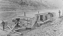
[17] In his 1884 book Woodcraft he wrote of the Pine Creek watershed where A huge tannery ... poisons and blackens the stream with chemicals, bark and ooze.
At last he reached "The Point", which he wrote was "the jutting terminus of a high ridge which not only commands a capital view of the opposite mountain, but also of the Pine Creek Valley, up and down for miles".
[29][30] In 1936, the year the park opened, Larry Woodin of Wellsboro and other Tioga County business owners began a tourism campaign to promote the Pine Creek Gorge as "The Grand Canyon of Pennsylvania".
New facilities were added in 1938, and included buildings such as picnic pavilions, latrines, and a concession stand, as well as "stone cook stoves, tables, and developed trails and overlooks ... an amazing amount of work in one year".
Additional structures constructed by the CCC include three overlooks and a rectangular gable-roofed maintenance building with wane edge siding and exposed rafters made of logs.
There was much local opposition to its inclusion, based at least partly on mistaken fears that protection would involve seizure of private property and restricted access.
Pine Creek had flowed northeasterly until then, but was dammed by rocks, soil, ice, and other debris deposited by the receding Laurentide Continental Glacier.
[47] The land on which Colton Point State Park sits was once part of the coastline of a shallow sea that covered a great portion of what is now North America.
The high mountains to the east of the sea gradually eroded, causing a buildup of sediment made up primarily of clay, sand and gravel.
Tremendous pressure on the sediment caused the formation of the rocks that are found today in the Pine Creek drainage basin: sandstone, shale, conglomerates, limestone, and coal.
The youngest of these, which forms the highest points in the park and along the gorge, is the early Pennsylvanian Pottsville Formation, a gray conglomerate that may contain sandstone, siltstone, and shale, as well as anthracite coal.
Pine Creek was home to large predators such as wolves, lynx, wolverines, panthers, fishers, bobcats and foxes; all are locally extinct except for the last three as of 2007.
The creeks and runs flowed more evenly year-round, since centuries of accumulated organic matter in the forest soil caused slow percolation of rainfall into them.
[55][56] Pine Creek was home to large numbers of fish, including trout, but dams downstream on the Susquehanna River have eliminated the shad, salmon,[d] and eels once found here by blocking their migrations.
[57] In 1988 the Pennsylvania Department of Environmental Resources, precursor to the DCNR, described it as about 95% State owned, unroaded, and designated the Pine Creek Gorge Natural Area.
It is a place of unique geologic history and contains some rare plant communities, an old growth hemlock stand, ... active bald eagle nest[s] ... and is a major site of river otter reintroduction.
[59] Colton Point State Park's extensive forest cover makes it a habitat for "big woods" wildlife, including white-tailed deer, black bear, wild turkey, red and gray squirrels.
[56] Colton Point State Park is part of Important Bird Area #28, which encompasses 31,790 acres (12,860 ha) of both publicly and private held land.
[60] Colton Point State Park has some challenging hikes in and around the Grand Canyon of Pennsylvania, with 4.0 miles (6.4 km) of trails that feature very rugged terrain, pass close to steep cliffs, and can be very slick in some areas.
The common game species are ruffed grouse, eastern gray squirrels, wild turkey, white-tailed deer, and black bears.
[9] Historically, the stretch of Pine Creek in the park has been fished by notable anglers, including President Theodore Roosevelt and Pennsylvania Governor William A.