Columbia River Basalt Group
[3] The Latah Formation sediments of Washington and Idaho are interbedded with a number of the Columbia River Basalt Group flows, and outcrop across the region.
As the molten rock came to the surface, the Earth's crust gradually sank into the space left by the rising lava.
The lava, as it flowed over the area, first filled the stream valleys, forming dams that in turn caused impoundments or lakes.
[5][6] In the middle Miocene, 17 to 15 Ma, the Columbia Plateau and the Oregon Basin and Range of the Pacific Northwest were flooded with lava flows.
Comparative analysis of volatile concentrations in source feeder dikes to associated extruded flow units have been quantitatively measured to determine the magnitude of degassing exhibited in CRBG eruptions.
As the North American Plate moved several centimeters per year westward, the eruptions progressed through the Snake River Plain across Idaho and into Wyoming.
Using tomographic images based on seismic waves, relatively narrow, deeply seated, active convective plumes have been detected under Yellowstone and several other hot spots.
Further, the Yellowstone images show necking of the plume at 650 and 400 km (400 and 250 mi), which may correspond to phase changes or may reflect still-to-be-understood viscosity effects.
The cooling/hydraulics analyses are supported by an independent indicator; if longer periods were required, external water from temporarily dammed rivers would intrude, resulting in both more dramatic cooling rates and increased volumes of pillow lava.
These techniques have been key to correlating data from disparate basalt exposures and boring samples over five states.
Each distinct layer is typically assigned a name usually based on area (valley, mountain, or region) where that formation is exposed and available for study.
[23] The Steens Basalt captured a highly detailed record of the Earth's magnetic reversal that occurred roughly 15 million years ago.
However, several of the flows, which freeze from both the upper and lower surfaces, progressively toward the center, captured substantial variations in magnetic field direction as they froze.
[24] The Steens Basalt flows covered about 50,000 km2 (19,000 sq mi) of the Oregon Plateau in sections up to 1 km (3,300 ft) thick.
[26] Steens Mountain and related sections of Oregon Plateau flood basalts at Catlow Peak and Poker Jim Ridge 70 to 90 km (43 to 56 mi) to the southeast and west of Steens Mountain, provide the most detailed magnetic field reversal data (reversed-to-normal polarity transition) yet reported in volcanic rocks.
Many of the dikes were fissures 5 to 10 m (16 to 33 ft) wide and up to 10 miles (16 km) in length, allowing for huge quantities of magma upwelling.
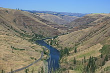
Grande Ronde basalt flows and dikes can also be seen in the exposed 2,000-foot (610 m) walls of Joseph Canyon along Oregon Route 3.
[34] The Grande Ronde basalt flows flooded down the ancestral Columbia River channel to the west of the Cascade Mountains.
The McCoy Canyon flow of the Sentinel Bluffs Member released 4,278 km3 (1,026 cu mi) of basalt in layers of 10 to 60 m (33 to 197 ft) in thickness.
The Pruitt Draw flow of the Teepee Butte Member released about 2,350 km3 (560 cu mi) with layers of basalt up to 100 m (330 ft) thick.
The Frenchman Springs Member flowed along similar paths as the Grande Ronde basalts, but can be identified by different chemical characteristics.
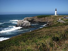
It flowed west to the Pacific, and can be found in the Columbia Gorge, along the upper Clackamas River, the hills south of Oregon City.
[40] Camp & Ross (2004) observed that the Oregon High Lava Plains is a complementary system of propagating rhyolite eruptions, with the same point of origin.