Conemaugh River
It flows generally west–northwest, in a winding course through the mountains along the northern edge of Laurel Hill and Chestnut Ridge.
Along much of its lower course, the Conemaugh forms part of the boundary between Westmoreland and Indiana counties.
The Kiskiminetas-Conemaugh river basin flows through scenic mountainous country that forms the heart of the historic coal-producing areas of western Pennsylvania.
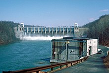
Before the Dam was constructed, the town of Livermore served the area between Blairsville and Saltsburg as an important stop along the former canal, as well as the railroad.
The recovery of the river has been an important ongoing ecological management project of state and private agencies.