Congress Heights
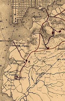
The United States Department of War constructed the George Washington Young cavalry magazine on 90 acres (360,000 m2) of land on Giesborough Point.
After the war, the 375-acre (1,520,000 m2) Barry Farm housing development for freed slaves opened in 1867 on the north side of the St. Elizabeths campus and was rapidly occupied.
The only other major street was a military road (now known as Alabama Avenue SE) which ran in an east-northeasterly direction toward other Civil War forts.
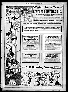
Colonel Arthur E. Randle,[a][9] a successful newspaper publisher, decided to found a settlement east of the river which he called Congress Heights.
[12] Randle understood that this new bridge would bring rapid development east of the Anacostia River, and he intended to take advantage of it.
[13][b][14][15][16] On March 2, 1895, Randle founded the Capital Railway Company to construct streetcar lines over the Navy Yard Bridge and down Nichols Avenue to Congress Heights.
Randle sold his interest in the Capital Railway in 1899,[17] and used this fortune to buy a large section of land known as "East Washington Highlands" at the foot of the Pennsylvania Avenue Bridge.
Beginning near St. Elizabeths Hospital, a line of bluffs extended roughly southward until it reached what is now Chesapeake Street SW. (Fort Greble sat atop the southernmost of these cliffs.)
To the west of these bluffs were broad, flat lowlands which provided pleasant views of the Potomac River and the city of Alexandria, Virginia.
Nineteen development projects worth a total of $455 million are underway or completed in Congress Heights as of November 2006.
Among these are a redevelopment of St. Elizabeths West Campus for federal use; a request for proposals from the Washington Metropolitan Area Transit Authority for the area around the Congress Heights Metro station; and a planned redevelopment of Camp Simms as a mixed-use project, including a new Giant Grocery Store, enhancement to an existing shopping center, and 75 new residential units.
The main street program is based on the National Trust for Historic Preservation nationally proven model The Main Street Four Point Approach which includes in emphasis in the areas of: organization of commercial revitalization efforts, promotion of neighborhood businesses and business districts, design and economic revitalization.