Conservation in Belize
These acts have established a number of different types of protected areas, with each category having its own set of regulations dictating public access, resource extraction, land use and ownership.
In Belize, the reef's rich diversity of corals and other marine life has qualified it to be designated a World Heritage Site, in recognition of its consequent global importance.
[15] Belize is party to a number of legally binding multilateral environmental agreements, many of which deal with proper management of the country's natural resources.
[17] Since its ratification of the Ramsar Convention in 1998, Belize has had two sites designated as wetlands of international importance: Crooked Tree Wildlife Sanctuary, in 1998, and Sarstoon-Temash National Park, in 2005.
[18] In October 2003, the Ministry of Natural Resources and the Environment began developing a comprehensive "National Protected Areas Policy & System Plan", which focuses on establishing a balance between environmental conservation and the need for economic development, as well as on rationalising the allocation of financial funding and human resources across the protected areas system.
[5] Another ecotype identified as lacking proper attention was the country's deep water ecosystems, which had received neither formal protection nor any research into whether they should be.
[5] As part of an attempt to prioritise resource allocation (both human and financial) across the system, the protected areas were ranked on their ecological, socio-cultural and economic value.
When designing a particular park, care is taken to ensure that the area contains as many different ecosystems as possible, and allows enough space for populations of species to thrive.
In Belize, amphibian populations remain largely undetermined due to their isolation and probable scarcity,[21][24] and subsequently only fragmentary information is available on their status and distribution.
[25] From the mid-19th century, various scientific explorers such as Godman, Morelet and Salvin conducted herpetological research from samples collected in Belize and the surrounding Petén Basin.
This route, while still relatively healthy, is under constant threat from anthropogenic activities, including urban and coastal development and increasingly fragmented habitats.
Recent marked declines in certain species has spurred a growing interest in engaging locals at all levels to monitor avian populations.
[31] In 2004, BirdLife International, in partnership with the Belize Audubon Society, delineated six Important Bird Areas in the country,[16] each representing an average of 347 species.
[29] According to the Friends for Conservation and Development, charged with maintaining surveillance in the Chiquibul area, the breeding ground is a prime target for smugglers.
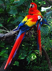
In 2009, ten macaws, valued at up to BZ$10,000, were reportedly taken from the Upper Macal by a single poaching party, and then sold in Las Flores, Guatemala.
[29]In Guatemala, the macaw population has been diminished primarily due to the robbing of chicks and consequently, we understood that the same fate was prone to occur in Belize.
... Loss of chicks at the hands of Guatemalan poachers engaged in the pet trade and the removal of the nesting habitat can wipe out the remaining wild populations of macaws in Belize in a few years.
In 2005, Jan Meerman, the leading biologist in the government's conservation review committee, wrote:Increasingly it becomes obvious that the long-term survival of jaguars in close proximity to human habitation and activities is unlikely.
Prior to its recent expansion, the reserve contained the highest density of jaguars ever recorded,[43] and is regarded as one of the most important areas for the conservation of the species.
[47] Fertile females contain sacks of roe that sell for up to four times more per pound than the actual fish itself,[49] meaning that in many cases individuals will be removed before they have had the chance to reproduce.
[47] Annual spawning occurs in specific locations on the outer reef shelf during the days around the full moon of December and January.
[48][50][51] This intensive harvesting of reproductively active individuals, often before they have had the chance to spawn,[50] has resulted in a marked decline in both abundance and size.
[52] In November 2002, under pressure from environmental organisations, the government agreed to protect 11 of these sites from commercial fishing during the spawning season.
[53][54][55] The most significant of these are at Glover's Reef and Sandbore Caye, which have been identified as the only two viable sites remaining for the species, of nine historically known locations.
[54] Its report of the 2009 spawning season at Glover's Reef concluded that numbers were still in decline, and that the majority of the individuals recorded were immature and less than the legal minimum landing size.
A study in January 2001 estimated that the value of the largest spawning aggregation sites, if fished, would be realised and exhausted within a decade, since the species would disappear with low chances of recovery.
[46] Following the Green Reef surveys, however, the closure and monitoring of remaining known aggregation sites was seen as essential to ensure their long-term viability, and subsequently the survival of both the species and the fishing industry that depends on it.
In 1959, a map was published estimating Belize's natural vegetation prior to colonial settlement of the territory, which showed forest cover at almost 89%.
[56] It drew on data from previous studies, but used remote sensing, and was recognised by the intergovernmental Group on Earth Observations (GEO), of which Belize is a member.
[58][60] Belize is a signatory to a number of multilateral environmental agreements requiring the regular monitoring of national forest cover and overall land use.