Cosumnes River
It rises on the western slope of the Sierra Nevada and flows approximately 52.5 miles (84.5 km)[2] into the Central Valley, emptying into the Mokelumne River in the Sacramento-San Joaquin Delta.
Towns and cities along the Cosumnes River include Plymouth, Rancho Murieta, Sloughhouse, Wilton, Elk Grove, and Galt.
Flowing from the western slope of the central Sierra Nevada mountains, the Cosumnes starts as North, Middle and South forks cutting canyons through the El Dorado and Amador County Gold Country before converging just east of Highway 49.
Below Omo Ranch it flows through a gentler valley, past Outingdale, then enters another short canyon where it receives the South Fork Cosumnes River from the left.
The Cosumnes River proper continues west, receiving Big Indian Creek from the south and passing under SR 49 (Golden Chain Highway).
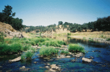
Below Highway 99 it enters the nearly 50,000-acre (20,000 ha) Cosumnes River Preserve, which include some of the largest remaining wetlands and riparian areas in the Central Valley.
However, its salmon and steelhead populations have been harmed by invasive fish species and pollution from illegal mining activity, as well as the two irrigation diversion structures near Rancho Murieta.
Sly Park Dam, which creates 41,000-acre-foot (51,000,000 m3) Jenkinson Lake, is the largest water storage facility in the Cosumnes River watershed.
Dams have been proposed to be built on the main stem to control flows, but these plans have largely stalled because of the river's unique free-flowing status and its importance as a wildlife habitat.
Sacramento County officials continue to lobby for the construction of a flood-control dry dam above Rancho Murieta at Michigan Bar.