County Kerry
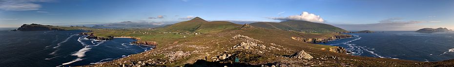
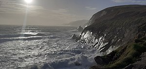
Its rugged coastline stretches for 886 kilometres (551 miles) and is characterised by bays, sea cliffs, beaches and many small offshore islands, of which the Blaskets and the Skelligs are the most notable.
The climate of Kerry is dominated by the North Atlantic Current and is usually mild and humid, with abundant precipitation.
The county town is Tralee although the Catholic diocesan seat is Killarney, which is one of Ireland's most famous tourist destinations.
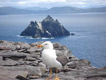
Skellig Michael is a World Heritage Site, famous for the medieval monastery clinging to the island's cliffs.
[8] In 1986 the remnants of Hurricane Charley crossed over Kerry as an extratropical storm causing extensive rainfall, flooding and damage.
Kerry (Irish: Ciarraí or in the older spelling Ciarraighe) means the "people of Ciar" which was the name of the Gaelic tribe who lived in part of the present county.
[13] On 27 August 1329, by Letters Patent, Maurice FitzGerald, 1st Earl of Desmond was confirmed in the feudal seniority of the entire county palatine of Kerry, to him and his heirs male, to hold of the Crown by the service of one knight's fee.
In 1588, when the fleet of the Spanish Armada in Ireland were returning to Spain during stormy weather, many of its ships sought shelter at the Blasket Islands and some were wrecked.
During the Nine Years' War, Kerry was again the scene of conflict, as the O'Sullivan Beare clan joined the rebellion.
Donal O'Sullivan Beare, in an effort to escape English retribution and to reach his allies in Ulster, marched all the clan's members and dependants to the north of Ireland.
His son the Earl of Clancarty held the county during the subsequent Irish Confederate Wars and his forces were among the last to surrender to the Cromwellian conquest of Ireland in 1652.
In the 18th and 19th centuries Kerry became increasingly populated by poor tenant farmers, who came to rely on the potato as their main food source.
As a result, when the potato crop failed in 1845, Kerry was very hard hit by the Great Irish Famine of 1845–49.
One exception existed in Listowel where a pro-Treaty garrison was established by local Flying Column commandant Thomas Kennelly in February 1922.
In the ensuing civil war between pro- and anti-treaty elements, Kerry was perhaps the worst affected area of Ireland.
Initially the county was held by the Anti-Treaty IRA but it was taken for the Irish Free State after seaborne landings by National Army troops at Fenit, Tarbert and Kenmare in August 1922.
The republicans, or "irregulars", mounted a number of successful actions, for example attacking and briefly re-taking Kenmare in September 1922.
In March 1923 Kerry saw a series of massacres of republican prisoners by National Army soldiers, in reprisal for the ambush of their men—the most notorious being the killing of eight men with mines at Ballyseedy, near Tralee.
The internecine conflict was brought to an end in May 1923 as the rule of law was re-established following the death of IRA Chief of Staff Liam Lynch, and the order by Frank Aiken to dump all arms.
[16] The county is divided into five municipal districts with local responsibility: Corca Dhuibhne–Castleisland, Kenmare, Killarney, Listowel, and Tralee.
The Sliabh Luachra area of northeast Kerry, that borders Limerick and Cork, is renowned for its traditional music, dance and song, especially its slides, polkas and fiddle playing.
Corca Dhuibhne and Uíbh Ráthach are considered Gaeltacht regions and Irish culture is also very strong in these areas.
The Blasket Islands off the Dingle Peninsula are known for their rich literary heritage; authors such as Peig Sayers, Muiris Ó Súilleabháin and Tomás Ó Criomhthain have all written books about life on the islands, which were evacuated in 1953 due to increasingly extreme weather conditions that made them uninhabitable.
John B Keane, a native of Listowel, is considered one of Ireland's greatest playwrights and is known for his works such as The Field, Sive and Big Maggie.
Tralee Dynamos have represented Kerry in the A Championship, while they and Killarney Celtic also competed in the Munster Senior League during the late 1990s and early 2000s.
[22] The county has a notably high concentration of open-air Atlantic rock art, which is believed to date to the Late Neolithic / Early Bronze Age period (2300-1500BC).
These carvings form part of a tradition which stretches across Atlantic Europe and are distinct from the megalithic art of the type found at Newgrange.
Various local link services also run throughout Kerry such as the soon to be launched 274 from Tralee to Tarbert via Ardfert, Ballyheigue, Ballyduff and Ballybunion.
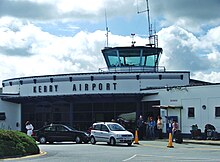
Destinations served as of 2014 are London (Stansted & Luton), Frankfurt-Hahn Airport, Faro, Portugal and Alicante all operated by Ryanair.
A number of Irish surnames are derived from septs who hail from the Kerry area, such as Falvey, Foley, McCarthy, Murphy, O'Connor, O'Moriarty, Clifford, Kennelly, McGrath, O'Carroll, O'Sullivan, O'Connell, O'Donoghue, O'Shea, Quill, Scannell, Stack, Sugrue and Tangney.