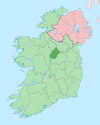
County Longford
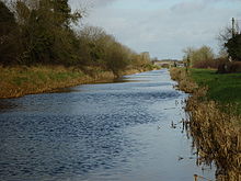
[3] Most of Longford lies in the basin of the River Shannon with Lough Ree forming much of the county's western boundary.
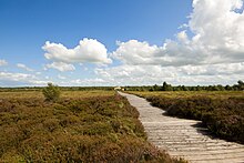
Lakeland, bogland, pasture-land and wetland typify Longford's generally low-lying landscapes: the highest point of the county is in the north-west – Carn Clonhugh (also known as Cairn Hill or Corn Hill) between Drumlish and Ballinalee in the parish of Killoe, at 278 metres (912 ft).
In the list of Irish counties by highest point, Longford ranks third lowest – only Meath and Westmeath have lower maxima.
The southern parts of the county are low-lying, with extensive areas of raised bogland and the land being of better quality for grazing and tillage.
Between the fifth and twelfth centuries, the territory was called the kingdom of Tethbae ruled by various tuath such as the Cairpre Gabra in the north.
Tethbae (Latin: Teffia) originally referred to an area north of the River Inny approximating to present-day County Longford.
[5][6] Following the Norman invasion of the 12th century, Annaly was granted to Hugh de Lacy as part of the Liberty of Meath.
The town of Granard was sacked by Edward Bruce's army in 1315, and the O'Farrells soon recovered complete control over the territory.
[7] The county was officially shired in 1586 in the reign of Elizabeth I from the northern portion of Westmeath,[8] but English control was not fully established until the aftermath of the Nine Years' War.