Middlesex
In the eighteenth and nineteenth centuries the population density was especially high in the southeast of the county, including the East and West Ends of London.
In 1855 the densely populated southeast, together with sections of Kent and Surrey, came under the Metropolitan Board of Works for certain infrastructure purposes, while remaining a part of Middlesex.
It is not known exactly when Middlesex was established as a county, possibly the early tenth century,[14] but it is clear that it did not cover the whole of the former Middle Saxon Province of Essex.
[1] When the railways were built, the north western suburbs of London steadily spread over large parts of the county.
[22] Local government in the county was unaffected by the Municipal Corporations Act 1835, and civic works continued to be the responsibility of the individual parish vestries or ad hoc improvement commissioners.
[7] In 1889, under the Local Government Act 1888, the metropolitan area of approximately 30,000 acres (120 km2) became part of the administrative County of London.
[31] The expanding urbanisation had, however, been foretold in 1771 by Tobias Smollett in The Expedition of Humphry Clinker, in which it is said: Pimlico and Knightsbridge are almost joined to Chelsea and Kensington, and, if this infatuation continues for half a century, then, I suppose, the whole county of Middlesex will be covered in brick.
New Brentford was first promulgated as the county town in 1789, on the basis that it was where elections of knights of the shire (or Members of Parliament) were held from 1701.
[25][37] Thus a traveller's and historian's London regional summary of 1795 states that (New) Brentford was "considered as the county-town; but there is no town-hall or other public building".
In the interwar years, suburban London expanded further, with improvement and expansion of public transport,[8] and the setting up of new industries.
[30][40] According to the 1961 census, Ealing, Enfield, Harrow, Hendon, Heston & Isleworth, Tottenham, Wembley, Willesden and Twickenham had each reached a population greater than 100,000, which would normally have entitled each of them to seek county borough status.
If this status were to be granted to all those boroughs, it would mean that the population of the administrative county of Middlesex would be reduced by over half, to just under one million.
[41] The Administration of Justice Act 1964 abolished the Middlesex magistracy and lieutenancy, and altered the jurisdiction of the Central Criminal Court.
[9] Following the changes, local acts of Parliament relating to Middlesex were henceforth to apply to the entirety of the nine "North West London Boroughs".
The one named "Middlesex" consisted of the boroughs of Barnet, Brent, Ealing, Enfield, Haringey, Harrow, Hillingdon and Hounslow.
[25] The county lay within the London Basin[50] and the most significant feature was the River Thames, which formed the southern boundary.
[17] A variety of goods were provided for the City, including crops such as grain and hay, livestock and building materials.
Tourism began to develop in the late 16th century and, in 1593, John Norden noted that the county was attracting visitors to its "divers devices, neatly decked with rare inventions, environed with orchards of sundry delicate fruits, gardens with delectable walks, arbours, alleys, and great variety of pleasing dainties.
"[57] Inns and tea gardens at Isleworth, Tottenham, Edmonton and Hornsey are noted in the 17th and 18th centuries for attracting day-trippers from London.
[17] In 1794, Thomas Cox wrote of Middlesex: We may call it almost all London, being chiefly inhabited by the citizens, who fill the towns in it with their country houses, to which they often resort that they may breathe a little sweet air, free from the fogs and smoke of the City.
[59]In 1803, Sir John Sinclair, president of the Board of Agriculture, spoke of the need to cultivate the substantial Finchley Common and Hounslow Heath (perhaps prophetic of the Dig for Victory campaign of World War II) and fellow Board member Middleton estimated that one tenth of the county, 17,000 acres (6,900 ha), was uncultivated common, capable of improvement.
[60] However, William Cobbett, in his Rural Rides first serialised in 1822, said that Thomas Babington wrote in 1843, "An acre in Middlesex is worth a principality in Utopia"[62] which contrasts neatly with its agricultural description.
[36] Tottenham, Edmonton and Enfield in the north developed first as working-class residential suburbs with easy access to central London.
[36] After World War I, the availability of labour and proximity to London made areas such as Hayes and Park Royal ideal locations for the developing new industries.
[63] Counties were an element of postal addressing in routine use until 1996, intended to avoid confusion between post towns, and are no longer required for the routing of the mail.
In 1965, Royal Mail retained the postal county because it would have been too costly to amend addresses covering the bulk of Outer London.
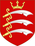
That assigned to the Kingdom of Essex, of which the Middle Saxon Province was part, depicted three "seaxes" or short notched swords on a red background.
Colonel Otley Parry, a justice of the peace for Middlesex and author of a book on military badges, was asked to devise an addition to the shield.
[76] Seaxes were also used in the insignia of many of the boroughs and urban districts in the county, while the Saxon crown came to be a common heraldic charge in English civic arms.
[96] Middlesex County Badminton Association has over 80 affiliated clubs and organises men's, ladies' and mixed leagues.