Cowal
Cowal (Scottish Gaelic: Comhghall)[1] is a rugged peninsula in Argyll and Bute, on the west coast of Scotland.
The landscape is mountainous, the high ground dominated by moorland, peat mosses and the forest that often extends down the sides of the sea lochs to the water's edge.
A smaller cist in the centre contained a bowl, burnt bone, charcoal and flint chips, and in the clay below them, the remains of a burial.
Following a subsequent invasion by Norsemen, the Hebridean islands of Dal Riata became the Kingdom of the Isles, which following Norwegian unification became part of Norway, as Suðreyjar (historically anglicised as Sodor).
However, an 11th-century Norse military campaign led to the formal transfer of Lorn, Islay, Kintyre, Knapdale, Bute, and Arran, to Suðreyjar.
Although, following the Treaty of Perth, Suðreyjar's successor state, the Lordship of the Isles, fell under the nominal authority of the Scottish king, it was not until 1475 that it was merged with Scotland (the occasion being the punishment of its ruler for an anti-Scottish conspiracy).
Seemingly, in the 11th century, an unidentified heiress of the Cenel Comgaill married Anrothan, grandson of the king of the Cenél nEógain, from Ulster.
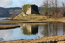
Clan traditions argue that Anrothan's lands were passed down to a descendant named Aodha Alainn O'Neil, who had the following sons: Excavations carried out at Castle MacEwen showed the site had several stages of development before it was the defended medieval homestead of the MacEwens; at first there was a palisaded enclosure, and then a promontory fort with a timber rampart.
De Bruys expelled the English from Cowal, with the aid of the Campbells (who were based nearby at Loch Awe), and eventually defeated Balliol.
After the Jacobite rising of 1715 when James Francis Edward Stuart attempted to regain the throne, the lack of roads in the Highlands prevented the British army from advancing to quell areas of unrest.
General Wade was tasked with implementing a programme to build military roads from north-central Scotland through the Highlands to the forts in the Great Glen.
William Caulfeild succeeded Wade in 1740 and constructed the road from Dumbarton via Tarbet to Inveraray through the Cowal where it is known as the "Rest and Be Thankful".
Steam propulsion started in 1812 and by the end of the 19th century, paddle steamers ferried thousands of Glaswegians doon the watter from Broomielaw in the city centre to holiday resorts including Dunoon on the Cowal.
It partly follows or runs parallel to William Caulfield's historic military road that takes its name, Rest and Be Thankful from the stone seat erected at the summit at the head of Glen Croe.
The shortest and fastest routes from much of Cowal to the population centres of the Scottish central belt involve crossing the Firth of Clyde.
Western Ferries operates a high-frequency vehicle carrying service between Hunters Quay, near Dunoon, and McInroy's Point, on the outskirts of Gourock in Inverclyde.
[23][24][25] Further south and west, Caledonian MacBrayne vehicle ferries provide crossings both to the Isle of Bute and to Kintyre.