Crickhowell
Crickhowell (/krɪkˈhaʊəl/; Welsh: Crucywel pronounced [krɨkːəu̯ɛl], non-standard spelling Crughywel) is a town and community in southeastern Powys, Wales, near Abergavenny, and is in the historic county of Brecknockshire.
The town lies on the River Usk, on the southern edge of the Black Mountains and in the eastern part of the Brecon Beacons National Park.
This is usually identified with the Iron Age hill fort on nearby Table Mountain, although this has the local name of Mynydd y Begwn.
In his 1893 book Wales and her language, John E. Southall, reports that over 60% of the population of Crickhowell spoke Welsh, although the town was only a few miles from more anglicised Abergavenny.
Other facilities in Crickhowell include a library, two play areas, public toilets and the CRiC building, which houses a tourist information centre, an internet cafe, an art gallery and a local history archive.
Many people visit Crickhowell to see the Black Mountains and the Brecon Beacons, and perhaps to enjoy some mountain-biking, camping, hillwalking, rock climbing, fly-fishing, hang-gliding or caravanning, or simply to tour the area by car, staying in bed-and-breakfast accommodation.
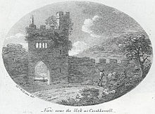
[17] Notable features in Crickhowell include the seventeenth-century stone bridge over the River Usk with its odd arches (twelve on one side, thirteen on the other) and its seat built into the walls, the 14th-century parish church of St Edmund, and the ruins of Crickhowell Castle on the green "tump" set back from the A40 Brecon to Abergavenny road.