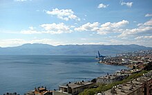
Croatian Littoral
[10] Rijeka Crikvenica The foothills of mountains that form the northeast boundary of the region, as well as islands in the Kvarner Gulf, are part of the Dinaric Alps, linked to a fold and thrust belt continuously developing from the Late Jurassic to recent times.
[12] The Dinaric Alps in Croatia encompass the regions of Gorski Kotar and Lika in the immediate hinterland of the Croatian Littoral, as well as considerable parts of Dalmatia.
[15] Though most of the soil in the region developed from carbonate rock, flysch is significantly represented on the Kvarner Gulf coast opposite Krk.
[16] The karst topography developed from the Adriatic Carbonate Platform, where karstification largely began after the final raising of the Dinarides in the Oligocene and Miocene epochs, when carbonate rock was exposed to atmospheric effects such as rain; this extended to 120 metres (390 ft) below the present sea level, exposed during the Last Glacial Maximum's sea level drop.
It is surmised that some karst formations are related to earlier drops of sea level, most notably the Messinian salinity crisis.
The bora is significantly conditioned by wind gaps in the Dinaric Alps bringing cold and dry continental air—the point where it reaches its peak speed is at Senj, with gusts of up to 180 kilometres per hour (97 kn; 110 mph).
The island became a part of the realm in 1481, but Venice never captured the region's mainland, which would have entirely linked Venetian possessions in the eastern Adriatic.
[47] As the region became a point of contention between the Habsburgs, Ottomans, and Venetians, its defense was given high importance in the newly established Croatian Military Frontier, as exemplified by the Uskoks of Senj.
[52] Days before the Battle of Waterloo, the Congress of Vienna awarded the Illyrian Provinces (spanning from the Gulf of Trieste to the Bay of Kotor) to the Austrian Empire.
[57] Illyria was abolished in 1849 and the crown lands of Carinthia, Carniola, and Austrian Littoral (German: Österreichisches Küstenland) were established in its place, with the latter including the Krk and Cres – Lošinj island groups.
[62][63] In 1918, a short-lived, unrecognised State of Slovenes, Croats and Serbs was formed out of parts of Austria-Hungary, comprising most of the former monarchy's Adriatic coastline and the entire present-day Croatian Littoral.
The new union's proponents at the time in the Croatian Parliament saw the move as a defence against Italian expansionism such as via provisions of the 1915 Treaty of London.
[64] The treaty was largely disregarded by Britain and France because of conflicting promises made to Serbia and a perceived lack of Italian contribution to the war effort outside Italy itself.
[67] After sixteen months of the Regency's existence, the 1920 Treaty of Rapallo redefined the Italian–Yugoslav borders, among other things transferring Zadar and the islands of Cres, Lastovo, and Palagruža to Italy, securing the island of Krk for Yugoslavia, and establishing the Free State of Fiume; this new state was abolished in 1924 by the Treaty of Rome that awarded Rijeka to Italy and Sušak to Yugoslavia.
[71] Since classical antiquity, the area around Kvarner Bay has been characterized as a meeting point of diverse cultures—from Hellenic and Roman cultures, through the Middle Ages and a succession of various rulers, to the present day.
[73] Crossbowmen from Rab are a living history company reenacting an arbalest tournament first held in 1364 to commemorate the successful defence of the island using that weapon.
A typical decorative motif used in the region is morčić (plural: morčići)—a dark skinned Moor used as a centerpiece on jewelry, usually earrings.
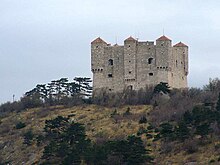
There are preserved examples of the Romanesque architecture on the island of Krk, in Vinodol, and in the Kastav area—largely churches, monasteries, and fortifications such as Drivenik Castle.
Several preserved examples of Gothic churches exist on the mainland, but during the Renaissance, construction largely consisted of fortifications because of the Ottoman conquest of the hinterland of the region.
They include the castles of Trsat, Grobnik, Bakar, Kraljevica, Ledenice, Bribir, Hreljin, Grižane, Novi Vinodolski, Krk, Drivenik and Gradec near Vrbnik.
These include Ivan Mažuranić—one of the foremost authors of Croatian literature in the first half of the 19th century—Janko Polić Kamov, Ödön von Horváth, and many others.
20th-century artists born or active in the region are Romolo Venucci, Jakov Smokvina, Vladimir Udatny, Antun Haller, Ivo Kalina, Vjekoslav Vojo Radoičić, and many others.
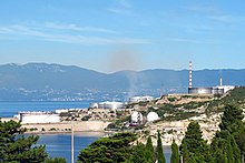
[78] The most significant economic activities in the Primorje-Gorski Kotar County are transport, largely based on activities of the Port of Rijeka, shipbuilding and tourism in the coastal areas representing a part of the Northern Croatian Littoral, and forestry and wood processing in the Gorski Kotar region in the hinterland.
[79] In the city of Rijeka itself, the most significant economic activities are civil engineering, wholesale and retail trade, transport and storage services, and the processing industry.
[80] Tourism, wood processing, and agriculture are the predominant economic activities in Lika-Senj County, where nearly all businesses are small and medium enterprises.