Cuillin
[4] The peaks of the Black Cuillin are mainly composed of gabbro, a very rough igneous rock which provides a superb grip for mountaineers; and basalt, which can be very slippery when wet.
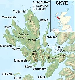
[6] The ridge is about 14 kilometres (8+1⁄2 miles) long (from Gars-bheinn in the south to Sgùrr nan Gillean in the northeast), and curves in an irregular semi-circle around Loch Coruisk, which lies at the heart of the range.
[3] The Red Cuillin are mainly composed of granite, which is paler than the gabbro (with a reddish tinge from some angles in some lights) and has weathered into more rounded hills with vegetation cover to summit level and long scree slopes on their flanks.
[5] The highest point of the red hills is Glamaig at 775 m (2,543 ft), one of only two Corbetts on Skye (the other being Garbh-bheinn, part of the small group of gabbro outliers surrounding Blà Bheinn).
Many iconic views of Scotland are centred here, whether Sgurr nan Gillean soaring above Sligachan, Loch Scavaig and the Cuillin ridge from Elgol, or Bla Bheinn above Torrin.There are several theories about the derivation of the name 'Cuillin'.
[11] Drummond later considered the Irish placename element cuilleann, meaning 'a steep slope', which is found in mountain names such as Slieve Gullion.
[13] The Cuillin provide classic examples of glacial topography and were the subject of an early published account by James Forbes in 1846 (who had become a fellow of the Royal Society of Edinburgh aged only nineteen).
[1] Due to the rocky nature of the Cuillin they have historically been of little use for agriculture: this contrasts with the majority of the highlands, where the hills were used to provide seasonal grazing for cattle and sheep.
Loch na h-Airde on the peninsula is linked to the sea by an artificial "Viking" canal that may date from the later period of Norse settlement.
[24] The MacDonalds and the MacLeods were bitter rivals, and two major battles of this period were fought between the clans at Harta Corrie and Coire Na Creich in the Cuillin: Boswell and Johnson visited Skye during their tour of the Western Isles in 1773, and observed snow falling on the summits of the range in September.
A deal was cut for the property to be gifted in return for repairs to the clan castle,[34] although it later fell through, with opponents arguing that the cost was out of proportion compared to other equivalent land sales.
[33] The Strathaird, Torrin and Sconser Estate lies on the eastern side of Glen Sligachan, encompassing the Red Cuillin and Bla Bheinn: it is owned by the John Muir Trust,[35] a charity that seeks to protect and enhance wild places.
Twelve Black Cuillin peaks are listed as Munros, though one of them, Blaven, is part of a group of outliers separated from the main ridge by Glen Sligachan.
Although only 11 km (7 mi) in length, the average traverse is likely to take 15–20 hours from sea level at Glenbrittle to the bar of the Sligachan Hotel, owing to the difficulty of the terrain and route-finding problems.
The record for the full traverse, set by Finlay Wild in October 2013, stands at 2 hours, 59 minutes and 22 seconds[40] (though this time is from Gars-bheinn to Sgùrr nan Gillean and does not include the initial ascent from Glenbrittle or the final descent to Sligachan).
[45] A longer challenge, known as the "Greater Traverse" includes all the Skye Munros, though omitting some gabbro outliers: this involves continuing on to Clach Glas and Blaven totalling some 20 km (12 mi) distance and 4,000 m (13,000 ft) ascent.