Cumulonimbus and aviation
Most thunderstorm-related crashes occur due to a stall close to the ground when the pilot gets caught by surprise by a thunderstorm-induced wind shift.
Two dangerous effects of cumulonimbus have been put forward to explain the crash of flight AF447 that sank into the sea on 31 May 2009 about 600 kilometres (370 mi) northeast of Brazil.
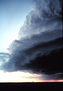
It encountered a mesoscale convective system in the Intertropical Convergence Zone (known by sailors as the "doldrums"), where cumulonimbus rise to more than 15 kilometres (49,000 ft) in altitude.
Small private airplanes are generally not equipped with on-board weather radars; and during an IFR approach, they can be sent accidentally by air traffic control to non-obvious active cells.
At this altitude, a phase change occurs where water droplets become ice crystals and therefore release energy in the form of latent heat and thus the updraft strength increases.
In the latter case, the updrafts can originate either from the ground (if the air is very dry – typical of deserts) or from aloft (when altocumulus castellanus degenerates into cumulonimbus).
Assuming that the glider is at cloud base height at 2,000 metres (6,600 ft), if it remains in the downdraught the entire time, it will only be able to glide 6 kilometres (3.7 mi) before being forced to land – likely under difficult and dangerous conditions.
Moreover, close to the ground, a glider or airplane pilot can be caught by surprise by a sudden reversal of the wind direction and transition from an upwind to a downwind situation.
If this airspeed drop occurs during the transition from the base leg to the final approach, the aircraft may enter into a spin from which there isn't enough altitude to recover.
For example, during the 1972 World Soaring Championship at Vršac, Yugoslavia, Helmut Reichmann attempted to use the violent updraughts associated with cumulonimbus.
[17] In the same book, the author narrates that an Italian instructor at Rieti had his students climb 10,000 metres (33,000 ft) inside cumulonimbus so that they get accustomed to them.
[26] As mentioned above, a climb inside a cumulonimbus can be initially very smooth (due to the negative buoyancy of the air parcel) and suddenly become horribly turbulent.
[29] A skydiver or paraglider pilot under a cumulonimbus is exposed to a potentially deadly risk of being rapidly sucked up to the top the cloud and being suffocated, struck by lightning, or frozen.
[31] When the pilot exits the updraught zone, he will encounter very strong turbulence due to the shear between rising and sinking air.
The crash of Flight AF 447 is indirectly related to this situation: the pilot opted for the shortest path while crossing the thunderstorm line associated with the Intertropical Convergence Zone, and the pitot tubes iced over.
Also, St. Elmo's fires while flying inside cumulonimbus can burn out the on-board electronic equipment and even pierce a wing by melting the metal skin.
Also, any winch launch is discouraged when a thunderstorm is less than 20 kilometres (12 mi) away, because the air is electrified, and the cable will act as a lightning rod.
The pilot was flying in eerily calm air (the updraught zone can be laminar) when he saw the sky transitioning from pale grey to inky black.
[34][35] An EF5 tornado can generate ground winds of unbelievable speed; common sense dictates that an aircraft should never be close to such a meteorological phenomenon.
An empirical criterion for tornado formation has been developed by Dan Sowa from Northwest Orient Airlines as follows: the cumulonimbus overshooting top must enter into the stratosphere by at least 10000 feet.
The reference to the thunderstorm front corresponds to the outflow boundary associated with downbursts that are indeed very dangerous and are the site of vortices associated with the Kelvin-Helmholtz instability at the junction between updraughts and downdraughts.
(Translation: The cumulonimbus is also the site of updraughts and downdraughts of speeds of 15 to 20 m/s generating considerable turbulence, likely to imperil the structure of most robust airplanes.
Dominique Musto cautions paraglider pilots (that might otherwise be swayed by the above myth) against the false sensation of safety in a region of extended updraughts that are rather weak as follows: Pourtant malgré un ciel sombre et l'absence de soleil, les ascendances sont douces et généralisées dans tout le secteur.
[46] Therefore, when a glider pilot is in an area where "updraughts are everywhere" and he is close to large clouds (that can be cumulus congestus), he is likely in the vicinity of a building thunderstorm.
For example, during an official contest of the Soaring Society of America, pilots openly played with the cumulonimbus (and even with the updraughts contiguous to downbursts) and boasted about it.
Moreover, if for any reason the pilot must land (hail storm or other), he will have to cross the downburst immediately above him and there will be a greatly increased chance of crashing – due to the unpredictable decrease of the airspeed.
Moreover, if the glider transitions from the updraught to the downdraught, severe turbulence will occur due to the Kelvin-Helmholtz instability in the shear area.
[54][55] Dennis Pagen performed a similar flight in front of a supercell cumulonimbus during the Preliminaries of the hang glider 1990 World championship in Brazil[56][57] where he was able to fly 35 km at high speed without a turn.
Pagen acknowledges that his achievement was very risky, since hang gliders (and even more so paragliders) are significantly slower than sailplanes and can much more easily be sucked inside the cloud.
The above examples demonstrate that the different phenomena associated with cumulonimbus can jeopardise any type of aircraft and its occupants when the pilot flies in the vicinity and especially inside a thundercloud.