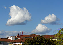
Cumulus cloud
They come in many distinct subforms and generally cool the earth by reflecting the incoming solar radiation.
The latter genus-type is sometimes categorized separately as cumulonimbiform due to its more complex structure that often includes a cirriform or anvil top.
[2] There are also cumuliform clouds of limited convection that comprise stratocumulus (low-étage), altocumulus (middle-étage) and cirrocumulus (high-étage).
[2] Cumulus clouds form via atmospheric convection as air warmed by the surface begins to rise.
At this point a positive feedback ensues: since the RH is above 100%, water vapor condenses, releasing latent heat, warming the air and spurring further convection.
In this phase, water vapor condenses on various nuclei present in the air, forming the cumulus cloud.
[4][5] The height of the cloud (from its bottom to its top) depends on the temperature profile of the atmosphere and of the presence of any inversions.
Langmuir was able to develop a formula[note 1] which predicted that the droplet radius would grow unboundedly within a discrete time period.
They form when wind shear causes horizontal circulation in the atmosphere, producing the long, tubular cloud streets.
These can occur when winds tear the cloud and incorporate the environmental air or when strong downdrafts evaporate the water.
[23] Cumulus mediocris clouds are similar, except that they have some vertical development, which implies that they can grow into cumulus congestus or even cumulonimbus clouds, which can produce heavy rain, lightning, severe winds, hail, and even tornadoes.
However, at the same time, they heat the earth by around 7 °C (13 °F) by reflecting emitted radiation, an effect largely caused by cirrus clouds.
The researchers speculated that this might even produce a positive feedback, where the increasing upper atmospheric moisture further warms the earth, resulting in an increasing number of cumulus congestus clouds carrying more moisture into the upper atmosphere.
[12] Cumulonimbus clouds, like cumulus congestus, extend vertically rather than remaining confined to one level.
They commonly appear in regular, rippling patterns[37] or in rows of clouds with clear areas between.
[39] Significant growth of these patches indicates high-altitude instability and can signal the approach of poorer weather.
[40][41] The ice crystals in the bottoms of cirrocumulus clouds tend to be in the form of hexagonal cylinders.
[42] These clouds do not last long, and they tend to change into cirrus because as the water vapor continues to deposit on the ice crystals, they eventually begin to fall, destroying the upward convection.
[43] Cirrocumulus clouds come in four species which are common to all three genus-types that have limited-convective or stratocumuliform characteristics: stratiformis, lenticularis, castellanus, and floccus.
[45] Altocumulus clouds can form via convection or via the forced uplift caused by a warm front.
Additionally, stratocumulus clouds reflect a large amount of the incoming sunlight, producing a net cooling effect.
On Mars, the Viking Orbiter detected cirrocumulus and stratocumulus clouds forming via convection primarily near the polar icecaps.
[51] The Galileo space probe detected massive cumulonimbus clouds near the Great Red Spot on Jupiter.
In 2008, the Cassini spacecraft determined that cumulus clouds near Saturn's south pole were part of a cyclone over 4,000 kilometres (2,500 mi) in diameter.