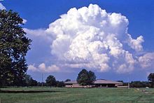
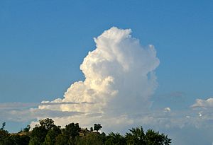
Cumulus congestus cloud
An approaching weather front often brings mid-level clouds (e.g. altostratus or altocumulus), which when expansive and dense, reduces insolation and infringes cumulus from reaching the congestus stage.
[citation needed] Cumulus congestus will develop into cumulonimbus calvus under conditions of sufficient instability.
Cumulus congestus can also be associated with fair weather waterspouts forming from rotation at the open water surface being stretched and tightened under their updraft.
Both of these non-mesocyclone associated tornadoes typically dissipate when a more pronounced precipitation shaft forms and the downdraft cuts off this process.
In highly sheared environments or within the flanking line of a supercell, congestus can rotate and, on rare occasions, produce mesocyclonic-type tornadoes, with waterspouts and landspouts emanating from misocyclones (a related but distinct process).