Cunninghamhead, Perceton and Annick Lodge
This mainly rural area is noted for its milk and cheese production and the Ayrshire, Cunninghame or Dunlop breed of cattle.
James Francis of Stane obtained most of the property and Roger de Blair of that Ilk,[1] a small portion, for which he had to annually pay twelve silver pennies or a pair of gilt spurs to the King.
The record of Lynns of Bourtreehill is as follows: On 7 Nov 1522, Robert Hunter resigned lands of Highlees [Dundonald] to John Lyn of Boutrehill.
On 21 January 1548, John Lyn of that Ilk and Bowtrehill conveyed the lands of Highlees to Archibald Crawford as guardian for the heir of Hunterston.
In 1621 William, son of John Cuninghame of Cunninghamhead holds the property and by 1661 it is in the hands of Hugh, later Earl of Eglinton.
He and his younger brother, John, ancestor of the Hamiltons of Sundrum, were long resident in Jamaica, where they possessed the estate of Pemberton valley, and acquired very considerable wealth.
In 1776, plate 45 of G. Taylor and A. Skinner's 'Survey and maps of the roads of North Britain or Scotland' shows Bourtreehill and gives the Countess of Crawfurd as proprietor.
Warrix (now Warrick) Hill also formed part of the demesne of the De Morvilles who forfeited their lands to Robert the Bruce.
This son had only a daughter as heir and she married Sir William Douglas and thus the property passed by marriage to the Barclay's of Pierstoun.
[2] This farm is shown on Pont's / Blaeu's 1654 map and it is close to the River Annick (previously Annock or Annack Water) in the area once known as Strathannick.
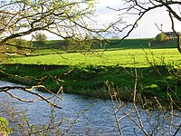
Langlands Farm overlooks the confluence of the Annick and the Glazert at Water Meetings; two high-arched bridges provide the road crossing.
Buried in St Maurs-Glencairn Kirk in Kilmaurs William and Mary King's gravestone reads "...late of Scrogiemill parish of Stewarton d. 3.6.1816 aged 61y.
The 'Place of the Crab apples' description fits well with the present appearance of the site which has an old wood next to it with a contiguous woodland recently planted by the farmer at Langlands.
The 1860 OS shows a lade running across the 'peninsula' of land made by the 'U' bend, with a dam across the river below Langlands farm forming a mill pond.
Steven[3] states that the representative of the family of Ross now the Earl of Glasgow, has inter alia the title of Lord Boyle of Stewarton, and at this date, January 1842, has now only about 12 acres (49,000 m2) in the parish, formerly called Crivochmill, but now commonly called Scrogmill where was till late, a meal - mill, now converted to a wool - spinning mill.
This farm has had many name and spelling changes with Shakhill from Ainslie's 1821 and Armstrong's 1775 maps, Rashshallhouse from Thomson's 1832 survey and Rashillhouse from 1895 onwards.
The first wheeled vehicles to be used in Ayrshire were carts offered gratis to labourers working on Riccarton Bridge in 1726 and even then some refused to use them.
with interest, as well as a further 50 shillings as the Fee and Wages for a herd for his cattle for five months during which his grounds were laid open by the alteration of the road.
[10] This seems to have happened all over Scotland, however Fife was more fortunate than Ayrshire, for the stones were taken into storage and put back in place after the war had finished.
In the winter season and during wet weather the road was impassable, even for travelling on horseback, nor could carriages of any kind pass along it.
The nearby law, next to the railway cutting, is shown on the 1897 OS, but it has now been 'ploughed out' The Barony of Kilmaurs was composed of the lands of Buston (now Buiston), Fleuris (now Floors), Lambroughton, whyrrig (now Wheatrig), and Southhook (otherwise Southwick, Southook, Southuck, Southeuk, Seurnhouck, Seurnbenck or Hooks (1775)) and therefore this area was associated with the Lands of Lambroughton.
In 1860 miners rows, coal pit, school and fireclay works were all located near the point where the Capringstone Burn passes under the road at what is now the Meadow Wood Community Woodland site.
Some confusion exists, for either an Archibald or a James Mure, burgess of Glasgow, married Margaret, daughter of Robert Ross of Thorntoun on 27 June 1607.
An Archibald Muir of Thorntoun was knighted by William III in 1699 and his daughter, Margaret, married John Cunningham of Caddell, in Ardrossan.
The Royal Mail re-organised its postal districts in the 1930s and at that point many hamlets and localities ceased to exist officially, such as Springside, with the loss of Springhill, Warrickhill Row, Bankhead and Little Kirkland .
To prevent the Covenanters holding 'Conventicles', King Charles II moved highland troops, the 'Highland Host' into the westland of Ayrshire.
Lawthorn Wood is a Scottish Wildlife Trust Nature reserve and from the old maps it seems to have been part of a swathe of woodland which ran on either side of the road to Glasgow in the heyday of the Eglinton Estate.
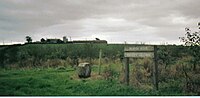
In 1820 Dreghorn Parish had only five people qualified to vote, these being the proprietors of Cunninghamhead, Annock Lodge, Langlands (2) and Warwickhill!
Aiton in 1811 mentions "a curious notion that has long prevailed in the County of Ayr, and elsewhere, that the wool of sheep was pernicious to the growth of thorns".
John Hasting's of West Lambroughton in 1995 recalled when the road was tarmaced as this made walking to the school awkward in hot weather as the tar melted and stuck to the soles of his feet.