Curtis, Michigan
As an unincorporated community, Curtis has no legally defined boundaries or population statistics of its own but does have its own post office with the 49820 ZIP Code.
Lee settled on a plot of land on the shores of South Manistique Lake, and other family members and settlers began moving to the area.
[9] Numerous cottages and resorts were constructed in hopes that Curtis would flourish when the area's lumber resources were exploited.
The community was able to sustain and steadily grow due to its proximity to numerous lakes that provided good hunting and fishing opportunities.
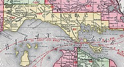
The community of Curtis is located within central Portage Township in the state's Upper Peninsula about 65 miles (105 km) west of the Mackinac Bridge.
H-42 has its eastern terminus at H-33 (Manistique Lakes Road) just east of the center of the community, and H-33 runs north to M-28 and south to U.S. Highway 2 (US 2).
Other nearby communities include Helmer and McMillan to the north, Germfask to the northwest, Blaney Park to the southwest, Gould City to the south, and Engadine to the southeast.
[23] Because of the community's close proximity to several lakes, the Michigan Department of Natural Resources maintains numerous public boat launches in the Curtis area.
The two closest to the center of the community are located along the southern shores of Manistique Lake with one along Long Road and another to the northeast in Portage Township Park.