Cycling in Madrid
The former city council had been planning to build 400 km more for the year 2024[1] despite a very vocal opposition to the construction of segregated infrastructure by a significant part[citation needed] of the local cycling community.
[2] However now with the new right wing mayor elected in 2019 the city is set to be the only capital in the world where bicycle lanes are being removed again.
This kind of infrastructure is marked with the drawing of a bicycle on the pavement and two "corporal" arrows (chevrons) that spans all the width of the lane.
This is by far the most usual kind of infrastructure that can be found in Madrid and the defining character of cycling in the city.
This means that the segregation between pedestrians and cyclists doesn't exist or there is a difference of less than 3 cm (1.2 in) between the height of the cycleway and the pavement.
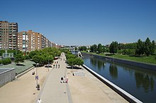
Shared-use paths, which are calle senda-bici in Spanish, are ways for pedestrians and cycles that run through open spaces, parks, gardens or forests, separated from road with motorized traffic.
The most important shared-use path is Madrid Río, a park located in the banks of the Manzanares River and opened in 2011.
Advances stop line are road markings near junction lights with the pictogram of a bicycle and a motorbike.
Advanced stop lines in Madrid doesn't have a feeder lane, so cyclists have to filter through cars in order to arrive there.
The Anillo Verde Ciclista (Cyclist Green Ring) is a bikeway that surrounds the city of Madrid.