Danevirke
This historically important linear defensive earthwork across the neck of the Cimbrian peninsula was initiated by the Danes in the Nordic Iron Age about AD 650.
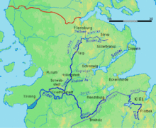
The walls stretch for 30 km, from the former Viking trade centre of Hedeby near Schleswig on the Baltic Sea coast in the east to the extensive marshlands in the west of the peninsula.
Fearing an invasion by the Franks, who had conquered heathen Frisia over the previous 100 years and Old Saxony in 772 to 804, Godfred began work on an enormous structure to defend his realm, separating the Jutland peninsula from the northern extent of the Frankish empire.
However, the Danes were also in conflict with the Saxons south of Hedeby during the Nordic Iron Age, and recent archaeological excavations have revealed that the Danevirke was initiated much earlier than King Gudfred's reign, at least as far back as 500 AD and probably well before that.
Throughout the nineteenth century, Denmark and Germany struggled politically and militarily for possession of the territory variously known as Sønderjylland or Slesvig by the Danes and Schleswig by the Germans.
In this hostile context, the Danevirke played an important role, at first as a mental cultural barrier against Germany, but soon also as a concrete military fortification, when it was strengthened with cannon emplacements and entrenchments in 1850 and again in 1861.
[10] The Danevirke began to lose its purpose in the 14th century, owing both to the expense of manning it and to the development of ballistas, trebuchets, and similar siege engines.
Due especially to the above-mentioned emotive nationalist symbolism, public opinion in Denmark and the Danish military had expected the coming battle to take place along the Danevirke.
It resulted, however, in the abandonment of important pieces of heavy artillery, and it remains a matter of historical debate why the railway to Flensburg was never properly used for the evacuation.
News of the retreat came as a great shock to Danish public opinion which had considered the Danevirke to be impregnable, and General de Meza was promptly relieved of his command.