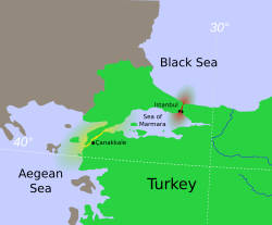
Dardanelles
Control over it has been an objective of a number of hostilities in modern history, notably the attack of the Allied Powers on the Dardanelles during the 1915 Battle of Gallipoli in the course of World War I.
Herodotus says that, circa 482 BC, Xerxes I (the son of Darius) had two pontoon bridges built across the width of the Hellespont at Abydos, in order that his huge army could cross from Persia into Greece.
Xerxes is then said to have thrown fetters into the strait, given it three hundred lashes with multiple whips and branded it with red-hot irons as the soldiers shouted at the water.
From the perspective of ancient Greek mythology Helle, the daughter of Athamas, supposedly was drowned at the Dardanelles in the legend of the Golden Fleece.
At the Istanbul Archaeological Museum a marble plate contains a law by the Byzantine Emperor Anastasius I (491–518 AD), that regulated fees for passage through the customs office of the Dardanelles.
The distinguished governor and major of the capital, who already has both hands full of things to do, has turned to our lofty piety in order to reorganize the entry and exit of all ships through the Dardanelles... ...
At the London Straits Convention in July 1841, the United Kingdom, France, Austria, and Prussia pressured Russia to agree that only Turkish warships could traverse the Dardanelles in peacetime.
In 1915 the Allies sent a substantial invasion force of British, Indian, Australian, New Zealand, French and Newfoundland troops to attempt to open up the straits.
The campaign damaged the career of Winston Churchill, then First Lord of the Admiralty (in office 1911–1915), who had eagerly promoted the (unsuccessful) use of Royal Navy sea power to force open the straits.
Sir Ian Hamilton's Mediterranean Expeditionary Force failed in its attempt to capture the Gallipoli peninsula, and the British cabinet ordered its withdrawal in December 1915, after eight months' fighting.
As part of its national security strategy, Turkey eventually rejected the terms of the treaty, and subsequently remilitarized the straits area over the following decade.
That convention, which is still in force today, treats the straits as an international shipping lane while allowing Turkey to retain the right to restrict the naval traffic of non-Black Sea states.
During World War II, through February 1945, when Turkey was neutral for most of the length of the conflict, the Dardanelles were closed to the ships of the belligerent nations.
In July 1946, the Soviet Union sent a note to Turkey proposing a new régime for the Dardanelles that would have excluded all nations except the Black Sea powers.
Russian oil, from ports such as Novorossyisk, is exported by tankers primarily to western Europe and the U.S. via the Bosporus and the Dardanelles straits.
The Dardanelles were closed in late February 2022 to all foreign warships at the beginning of the Russian invasion of Ukraine in accordance with the Montreux Convention.
[11] The waters of the Dardanelles are traversed by numerous passenger and vehicular ferries daily, as well as recreational and fishing boats ranging from dinghies to yachts owned by both public and private entities.
[14] 2 submarine cable systems transmitting electric power at 400 kV bridge the Dardanelles to feed west and east of Istanbul.
The first, situated in the northeast quarter portion of the strait, was energised in April 2015 and provides 2 GW via 6 phases 400 kV AC 3.9 km far through the sea.
[15] A published map shows communication lines leading from Istanbul into the Mediterranean, named MedNautilus and landing at Athens, Sicily and elsewhere.