De Biesbosch National Park
The eastern part of the Sliedrechtse Biesbosch is one of the few areas in the Netherlands that has an intact system of river dunes.
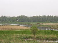
The Zuidwaard of the Brabantse Biesbosch has fewer fields of reeds and sedges compared to the rest of the National Park and consists mostly of willow forests.
Although the Dordtse Biesbosch has largely an agricultural destination, it also contains several recreational areas which serves as the "playground" for the people of Dordrecht.
In this way it can serve as a buffer and be of much importance in the prevention of dike breaks and subsequent flooding in densely populated areas in the Rhine-Meuse-Scheldt delta.
The more than a century old dikes collapsed because of lack of maintenance, due to the difficult economic situation in the area, and the difficulties between the political entities within (especially the Hook and Cod (civil) wars).
However, combined with political rivalry and financial issues, this resulted in the creation of an unstable dike, located at one of the key corners of the Grote Waard.
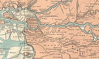
After the flood, three areas remained: the Island of Dordrecht to the west, the Land van Altena (with the city of Woudrichem) to the east, and the brackish swamps of the Biesbosch in between.
Many Rhine-Meuse delta branches that were closed off from the main rivers and served as drainage bodies of the Grote Waard, also disappeared.
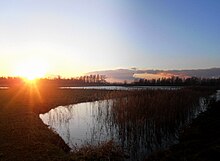
A network of interconnecting creeks, mudflats and forested areas arose, which served as a sort of inland delta of the large rivers feeding it.
A significant result of this was that the former estuary arms of the Rhine and Meuse, further north-west, were devoid of much of the inflow of fresh water.
This caused the rivers to fill with deposits, so the important shipping route between Rotterdam and the inland areas was no longer usable.
During World War II, the area was used by Dutch residents to hide out from the German occupation forces in the Netherlands.
A resistance group was formed that, late in the war, captured Germans fleeing to the north from what was then the Allied-held south of the Netherlands.
The tidal differences almost disappeared after 1970 when the Delta Works closed the Haringvliet and with it the Biesbosch's direct connection with the sea.
The diminishing of the tidal difference caused a dramatic transformation of the Biesbosch, which mostly changed into a willow forest with small remnants of the once mighty delta streams.
The Dutch government has decided to undo most of the reclamation and give it back to nature and to reconnect the main rivers with the Biesbosch creeks.
The area can then be used as a natural buffer to prevent major floods and to lower the risk of very high river levels.
One should note the fact that in times of severe floods coming from the North Sea, the dam will still be able to close and serve in a similar way as the Oosterscheldekering.
The partial opening of the Haringvlietdam will create an opportunity for migrating fish to enter the Rhine and Meuse rivers, restoring the natural situation.
Completely restoring the Biesbosch ecosystem cannot happen without an extensive cleanup of all the creeks, which will be an enormous and costly task.
Other threats include the construction of yacht-basins, urban expansion and plans for exploitation of natural gas reserves.