Death Valley National Park
[6] The park is home to many species of plants and animals which have adapted to the harsh desert environment including creosote bush, Joshua tree, bighorn sheep, coyote, and the endangered Death Valley pupfish, a survivor from much wetter times.
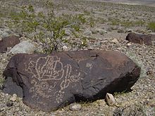
[7] A series of Native American groups inhabited the area from as early as 7000 BC, most recently the Timbisha around 1000 AD who migrated between winter camps in the valleys and summer grounds in the mountains.
Fast uplift of a mountain range in an arid environment often does not allow its canyons enough time to cut a classic V-shape all the way down to the stream bed.
[12] This topographic relief is the greatest elevation gradient in the contiguous United States and is the terminus point of the Great Basin's southwestern drainage.
It is so frequently the hottest spot in the United States that many tabulations of the highest daily temperatures in the country omit Death Valley as a matter of course.
[16][17] On the afternoon of July 10, 1913, the United States Weather Bureau recorded a high temperature of 134 °F (57 °C) at Greenland Ranch (now Furnace Creek) in Death Valley.
[9] The Death Valley region is a transitional zone in the northernmost part of the Mojave Desert and consists of five mountain ranges removed from the Pacific Ocean.
The Mesquite Flat dune field is the most easily accessible from the paved road just east of Stovepipe Wells in the north-central part of the valley and is primarily made of quartz sand.
One thousand years ago, the nomadic Timbisha (formerly called Shoshone and also known as Panamint or Koso) moved into the area and hunted game and gathered mesquite beans along with pinyon pine nuts.
In December 1849 two groups of California Gold Country-bound travelers with perhaps 100 wagons total stumbled into Death Valley after getting lost on what they thought was a shortcut off the Old Spanish Trail.
A memorable advertising campaign used the wagon's image to promote the Boraxo brand of granular hand soap and the Death Valley Days radio and television programs.
[38] President Herbert Hoover proclaimed a national monument in and around Death Valley on February 11, 1933, setting aside almost two million acres (8,100 km2) of southeastern California and small parts of Nevada.
Trails in the Panamint Range were built to points of scenic interest, and an adobe village, laundry and trading post were constructed for the Timbisha Shoshone Tribe.
[3] On October 31, 1994, the monument was expanded by 1.3 million acres (5,300 km2) and re-designated as a national park, via congressional passage of the California Desert Protection Act (Public Law 103–433).
[44] Many of the larger cities and towns within the boundary of the regional groundwater flow system that the park and its plants and animals rely upon are experiencing some of the fastest growth rates of any place in the United States.
[20] In 1977, parts of Death Valley were used by director George Lucas as a filming location for Star Wars, providing the setting for the fictional planet Tatooine.
The Pahrump is composed of arkose conglomerate (quartz clasts in a concrete-like matrix) and mudstone in its lower part, followed by dolomite from carbonate banks topped by algal mats as stromatolites, and finished with basin-filling sediment derived from the above, including possible glacial till from the hypothesized Snowball Earth glaciation.
A rift opened and subsequently flooded the region as part of the breakup of the supercontinent Rodinia in the Neoproterozoic (by about 755 million years ago) and the creation of the Pacific Ocean.
The Sierran Arc started to form to the northwest from heat and pressure generated from subduction, and compressive forces caused thrust faults to develop.
[53] A long period of uplift and erosion was concurrent with and followed the above events, creating a major unconformity, which is a large gap in the geologic record.
[54] No Jurassic- to Eocene-aged sedimentary formations exist in the area, except for some possibly Jurassic-age volcanic rocks (see the top of the timescale image).
[54] Basin and Range-associated stretching of large parts of crust below southwestern United States and northwestern Mexico started around 16 million years ago and the region is still spreading.
[57] Pleistocene ice ages started 2 million years ago, and melt from alpine glaciers on the nearby Sierra Nevada Mountains fed a series of lakes that filled Death and Panamint valleys and surrounding basins (see the top of the timescale image).
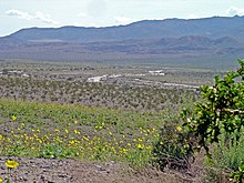
Death Valley is one of the hottest and driest places in North America, yet it is home to over 1,000 species of plants; 23 of which, including the very rare rock lady (Holmgrenanthe), are not found anywhere else.
This location, combined with the great relief found within the park, supports vegetation typical of three biotic life zones: the lower Sonoran, the Canadian, and the arctic/alpine in portions of the Panamint Range.
[61] Unlike more typical locations across the Mojave Desert, many of the water-dependent Death Valley habitats possess a diversity of plant and animal species that are not found anywhere else in the world.
[20] The existence of these species is due largely to a unique geologic history and the process of evolution that has progressed in habitats that have been isolated from one another since the Pleistocene epoch.
Costumed living history tours of the historic Death Valley Scotty's Castle were conducted for a fee, but were suspended in October 2015 due to extensive flood damage to the buildings and grounds.
[69] During the winter season—November through April—rangers offer interpretive tours and a wide variety of walks, talks, and slide presentations about Death Valley cultural and natural history.
The pools can be accessed by driving on the unpaved Saline Valley Road for several hours, or by flying a personal aircraft to the Chicken Strip—an uncharted airstrip a short walk from the springs.