Deep-ocean Assessment and Reporting of Tsunamis
By logging changes in seafloor temperature and pressure, and transmitting the data via a surface buoy to a ground station by satellite, DART enables instant, accurate tsunami forecasts.
A 2-way communication system allows the ground station to switch DART into Event Mode whenever detailed reports are needed.
At the start of event mode, the buoy reports measurements every 15 seconds for several minutes, followed by 1-minute averages for 4 hours.
In order to avoid false positives, the detection threshold was set relatively high, presenting the possibility that a tsunami with a low amplitude could fail to trigger the station.
The year of 2001 was the completion of the first six tsunami detection buoys placed along the northern Pacific Ocean coast.
This proposed system, stated by the John H. Marburger the White House's Office of Science and Technology Policy, should provide the United States' Tsunami Warning Centers with nearly one hundred percent coverage for any approaching tsunamis as well as decline all false alarms to just about zero.
[4] During all these improvements and upgrades of the current system, roughly three fourths of the tsunami warnings were discovered to be unnecessary and a waste of money.
The upgraded DART buoys were originally developed to maintain but to mostly improve the timing of detection of a tsunami.
In 2004, the DART® stations were transitioned from research at PMEL to operational service at the National Data Buoy Center (NDBC), and PMEL and NDBC received the Department of Commerce Gold Medal "for the creation and use of a new moored buoy system to provide accurate and timely warning information on tsunamis".
[6] In the wake of the 2004 Indian Ocean earthquake and its subsequent tsunamis, plans were announced to deploy an additional 32 DART II buoys around the world.
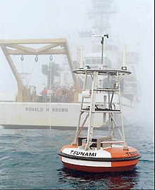
[8] The surface buoy has a two and a half meter diameter fiberglass disk covered with foam and has a gross displacement of 4000 kg.