Dells of the Wisconsin River
[3] The cliffs, some over 100 feet (30 m) high, and side canyons are closed to the public to protect sensitive ecological features.
The nearby city of Wisconsin Dells is the center of summer tourist activity, much of it in the form of the theme parks unrelated to the river features.
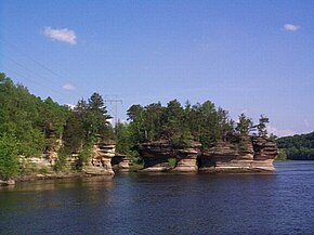
The eventual bursting of the ice dam unleashed a catastrophic flood, dropping the lake's depth to 50 feet (15 m) and cutting deep, narrow gorges and unusual rock formations into the sandstone seen today.
The cultural history of the area stretches back several thousand years, from early Paleo-Indian people to the more recent Native American peoples, such as Ho-Chunk, Sac, and Menominee, who left behind effigy and burial mounds, camps and village sites, garden beds, and rock art.
[5] The Kilbourn Dam, completed in 1909, raised the water level of the Upper Dells by about 17 feet (5.2 m), flooding some of the caves and rock formations in Bennett's photographs.