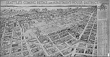
Denny Triangle, Seattle
The name Denny Triangle, referring to the northeastern portion of this regrading project, is a term that has gained currency as this neighborhood has seen increasing development in the first decades of the 21st century.
The Seattle City Clerk's Neighborhood Map Atlas (which is published by the city but does not have official status as defining neighborhoods) defines the Denny Regrade as bounded on the north by Denny Way, on the southwest by Third Avenue, on the southeast by Olive Way, with a small eastern border on Interstate 5.
[2] A 2009 map from northwestplaces.com treats the term "Denny Regrade" as synonymous with Belltown and shows both names as referring to a triangle bounded on the north by Denny Way, on the southwest by Western Avenue (two blocks inland of the Central Waterfront), and on the southeast by Stewart Street; the southern tip of this triangle falls in the northern part of Pike Place Market.
[4] Seattle is located on an isthmus between Lake Washington on the east and Puget Sound on the west.
The terrain was first gouged by south-moving glaciers, and when they retreated, was marked by mounds of rock debris left in their wake.