Deogarh, Uttar Pradesh
[1][2][3] The fort on the hill is dominated by a cluster of Jain temples on its eastern part, the oldest of these dating to the 8th or 9th century.
This term, "House of God", is also widely used as a place name for villages in the vicinity of temples within fort-walls throughout India.
[5] Deogarh village, which has an area of 1,049.15 square kilometres (405.08 sq mi),[1]: 104 lies on the right bank of the Betwa River, at the point where it joins the reservoir formed by the Rajghat Dam.
[1]: 105 Deogarh's strategic location in Northern India on the ancient route to the Deccan Plateau made it a historically important place.
Its antiquarian, archaeological and epigraphical importance are linked to the Gupta period and the Gurjara-Prathiharas during the 9th century (an inscription dated 862 found on the Shantinath temple attests this), the Chandela rulers in the 11th century, Gonds, the Muslim rulers of Delhi, the Marathas and the British eras.
[5][10] The present village's history has not been examined at depth, even though many inscriptions have been located in the fort and the valley, relating to various stylistic and palaeographical denominations.
More archaeological explorations would therefore be essential, to establish the linkages of building activities with the dynasties who ruled over the territory, considering the enormous amount of Hindu and Jain temple remains and artifacts found here.
[5] The earliest history of Deogarh is that of the architectural evolution traced to the ancient Gupta period, which flourished between the 4th and 6th centuries in Northern India.
Indian temple architecture emerged with figurine sculptures in decorative settings, attaining excellence of form.
[12] The Deogarh monuments can be categorized based on their location at valley and fort temples, which are generally built with sand stones of brick-red colour.
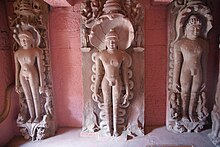
[15] The extravagance of the intricacies of the Jain sculptures are similar to that of nearby Gwalior in Madhya Pradesh and adjoining areas of Bihar.
The large number of idols lying scattered around the fort area is attributed to the fact that this was the sculptors' workshop.
This temple committee oversees the protection of the monuments and work to improve the ambience of the entire place.
It has been suggested however, that restoration works be carried out on more scientific terms, following guidelines set by UNESCO's World Heritage Sites.
Sculpted panels are seen on the terraced basement, with carved figurines of river goddesses Ganga and Yamuna flanking the doorway to the sanctum sanctorum.
In addition, on the side walls, three large carved panels of Vaishnava mythology related to Gajendra Moksha, the Nara Narayana Tapasya (austerities), and the Sheshashayi Vishnu (reclining on the serpent), are portrayed.
However, some believe that fort was built earlier by the Pratihara rulers of Kannauj in the 9th century, changed hands from the builders to the Chandelas and the Bundelas, before it came under the control of the Scindias of Gwalior.
[22][23] The fort has an external wall for the most part, except in stretches where the steep hill slopes towards the Betwa river.
The "Siddhi ki Ghufa" (Cave of the Saint), is an archaeological find, located on the cliff wall to the left, along the descent from the Nehar Ghat.
The Rajghat (Kings steps) also accommodate more than a dozen niches with lingas and statues, but the sculptures are small and in an unfinished state.
[24] Matrika statues (seated) are also important archaeological finds at the Nehar Ghat and Rajghat sections, as they establish early sculptural activity in the 6th century.