Gobi Desert
The Gobi Desert is the source of many important fossil finds, including the first dinosaur eggs, twenty-six of which, averaging 23 centimetres (9 in) in length, were uncovered in 1923.
[8] Archeologists and paleontologists have done excavations in the Nemegt Basin in the northwestern part of the Gobi Desert (in Mongolia), which is noted for its fossil treasures, including early mammals, dinosaur eggs, and prehistoric stone implements, some 100,000 years old.
[14] The Gobi Desert is expanding through desertification, most rapidly on the southern edge into China, which is seeing 3,600 km2 (1,390 sq mi) of grassland overtaken every year.
[16] The expansion of the Gobi is attributed mostly to human activities, locally driven by deforestation, overgrazing, and depletion of water resources, as well as to climate change.
[17] The Three-North Shelter Forest Program (or "Green Great Wall") is a Chinese government tree-planting project begun in 1978 and set to continue through 2050.
The goal of the program is to reverse desertification by planting aspen and other fast-growing trees on some 36.5 million hectares across some 551 counties in 12 provinces of northern China.
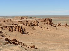
[18][19] The Gobi, broadly defined, can be divided into five distinct dry ecoregions, based on variations in climate and topography: The surface is extremely diversified, although there are no great differences in vertical elevation.
Broad flat depressions and basins are separated by groups of flat-topped mountains of relatively low elevation 150 to 180 m (490 to 590 ft), through which archaic rocks crop out as crags and isolated rugged masses.
Further south, between Iren-dutiasu-nor and the Yellow River, comes a region of broad tablelands alternating with flat plains, the latter ranging at altitudes of 1000–1100 m and the former at 1,070 to 1,200 m (3,510 to 3,940 ft).
The elevations do not form continuous chains, but make up a congeries of short ridges and groups rising from a common base and intersected by a labyrinth of ravines, gullies, glens, and basins.
But the tablelands, built up of the horizontal red deposits of the Han-gai (Obruchev's Gobi formation) which are characteristic of the southern parts of eastern Mongolia, are absent here or occur only in one locality, near the Shara-muren river.
The prevailing winds blow from the west and northwest, and the pall of dust overhangs the country as in the Taklamakan and the desert of Lop.
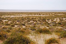
Characteristic of the flora are wild garlic, Kalidium gracile, wormwood, saxaul, Nitraria schoberi, Caragana, Ephedra, saltwort and the grass Lasiagrostis splendens.
[2] The taana wild onion Allium polyrrhizum is the main browse eaten by many herd animals, and Mongolians claim that this is essential in producing the proper, hazelnut-like notes of camel airag (fermented milk).
[2] "Topographically," says Nikolai Przhevalsky, "it is a perfectly level plain, which in all probability once formed the bed of a huge lake or inland sea."
He concludes this based on the level area of the region as a whole, the hard saline clay and the sand-strewn surface and, lastly, the salt lakes which occupy its lowest parts.
Although on the whole a level country with a general altitude of 1,000 to 1,500 m (3,300 to 4,900 ft), this section, like most other parts of the Gobi, is crowned by a network of hills and broken ranges of at least 300 m in elevation.
The vegetation is confined to a few varieties of bushes and a dozen kinds of grasses and herbs, the most conspicuous being saxaul (Haloxylon ammondendron) and Agriophyllum gobicum.
On the northern side, rivers formed from the snow and glaciers of the high mountains break through barren foothill ranges and flow out into an immense, hollow plain.
These two ranges mark the northern and the southern edges respectively of a great swelling, which extends eastward for nearly twenty degrees of longitude.
The Chol-tagh, which reaches an average altitude of 1,800 m (5,900 ft), is absolutely sterile, and its northern foot rests upon a narrow belt of barren sand, which leads down to the depressions mentioned above.
In the west, between Lake Bosten and the Tarim, it consists of two, possibly of three, principal ranges, which, although broken in continuity, run generally parallel to one another, and embrace between them numerous minor chains of heights.
Where such elevations exist, there is generally found, on the east side of the transverse ridge, a cauldron-shaped depression, which some time or other has been the bottom of a former lake, but is now nearly a dry salt-basin.
Most of the principal streams, instead of flowing straight down these valleys, cross them diagonally and only turn west after they have cut their way through one or more of the transverse barrier ranges.
This last, which is pretty certainly identical with the range of Kharateken-ula (also known as the Kyzyl-sanghir, Sinir, and Singher Mountains), that overlooks the southern shore of the Lake Bosten, though parted from it by the drift-sand desert of Ak-bel-kum (White Pass Sands), has at first a west-northwest to east-southeast strike, but it gradually curves round like a scimitar towards the east-northeast and at the same time gradually decreases in elevation.
The Kuruk-tagh is throughout a relatively low, but almost completely barren range, being entirely destitute of animal life, save for hares, antelopes and wild camels, which frequent its few small, widely scattered oases.