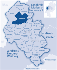
Dillenburg
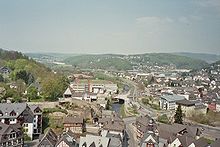
Dillenburg lies on the eastern edge of the Westerwald range in the narrow valley of the river Dill, which flows from Hesse-Westphalia border to Wetzlar, emptying into the Lahn.
Dillenburg is divided into the centres of Donsbach, Eibach, Frohnhausen, Manderbach, Nanzenbach, Niederscheld and Oberscheld.
The village, whose livelihood was once based on mining, lies among the other constituent communities of Nanzenbach, Oberscheld and Niederscheld.
With roughly 3,900 inhabitants, Frohnhausen is the largest of the constituent communities after the main town of Dillenburg.
The name comes from a small brook called the Schelde that rises between Oberscheld and Tringenstein and flows into the Dill at Niederscheld.
Towards the end of the Second World War, the village suffered comparatively heavy damage from Allied air raids.
Dillenburg Castle was built on top of the peak now called the Schlossberg in the late 13th or early 14th century.
In 1797, one of the earliest schools of forestry in Europe, founded a decade earlier at Hungen by Georg Ludwig Hartig, was moved to Dillenburg.
It continued in Dillenburg until 1805, when Hartig lost his position as Inspector of Forests for the Prince of Orange-Nassau, when the principality was dissolved by Napoleon.
In the 19th century came the Industrial Revolution with the building of the Deutz–Gießen railway and the use of iron ore found on the Lahn, Dill and Sieg.
In the Second World War, Dillenburg became a target of Allied attacks due to its marshalling yard.
In later years that yard was closed and ore mining became ever less profitable and in 1968, the last blast furnace, in Oberscheld, ceased operations.
(in each case on 31 December) The oldest town seals, dating from the 15th to 19th centuries, show the same composition as Dillenburg's current civic coat of arms.
As a result of the bankruptcy of the contractor for the works, Walter Bau, completion of the project was delayed by more than a year.