District C
It is roughly bounded by N. Hampshire Lane, Hollis, Canal, and Bridge streets, and was added to the National Register of Historic Places on November 12, 1982.
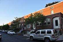
It originally contained nine rowhouses in an area of approximately 5 acres (2 ha);[1] three have subsequently been demolished and replaced by an apartment complex.
District C is a roughly rectangular area, located east of the mills formerly of the Amoskeag Manufacturing Company lining the eastern bank of the Merrimack River, and west of Elm Street, the city's principal commercial thoroughfare.
They are covered by dormered hip roofs, and entrances are set in pairs under Stick style hoods.
[2] Four of the district's nine blocks were built in 1881 by the Amoskeag Company, and are the survivors of seven originally built at that time to a design by the company's civil engineer, George W. Stevens.