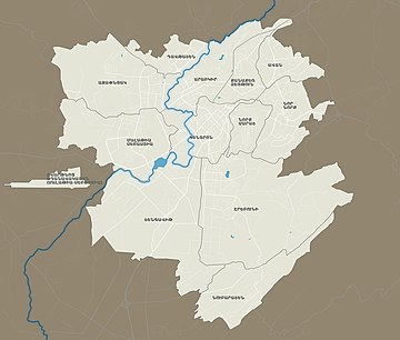
Districts of Yerevan
Yerevan is divided into twelve "administrative districts" (վարչական շրջաններ), each with an elected community leader.
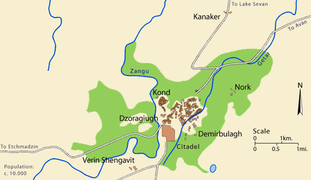
[2][3][4][5] Since the 17th century, without the fortress and nearby villages (Noragyugh, Dzoragyugh and Nork), Yerevan was divided into three main quarters (mahlas; Persian: محله): The market (Ghantar) was separate, between Kond and Shahar.
First time it was mentioned as old Yerevan or the old city of Yerevan by bishop Pilipos of Bjni in 1631:[7][8] …after many searches I found it [the Bible] in the old city of Yerevan…Բազում որոնմամբ խուզեալ գտաք, զգանձս զայս անգին ի հին քաղաքն Երեւան բազում ժամանակաւ գերի տարեալ ումեք իբրեւ եօթանասնօքKond (Armenian: Կոնդ), so-named because of its high position.
According to Hovhannes Shahkhatunyants, an Armenian historian, Kond located in the western and southern hillsides and foot of a rocky hill with similar name.
Later, Karahank was inhabited with newcomer Tatars (Azerbaijanis) and became part of Yerevan forming a separate district.
[10][11] Demir-Bulagh become crowded in the 17th century, when terrified of the Persian invasions, many Turks from Nakhichevan moved to the areas north to the Yerevan Fortress.
Ghantar (Armenian: Ղանթար, meaning "big scales in a marketplace", from Arabic: قنطار, qinṭār) was the active and business center of Yerevan.
After Erivan was taken over by the Russian troops in 1827, many Armenians from northern Persia came to Eastern Armenia, including to Yerevan.
Dzoragyugh was called Khnkadzor or Khnkelo, because it was Yerevan's bishop's seat, the word "khunk" means 'incense' in Armenian.
Dzoragyugh had three smaller neighborhoods: Nork (Armenian: Նորք, Turkish: Çömlekçi, meaning "potter") was the second villages near Yerevan, that became its part in the 1830s.
Nor tagh (Armenian: Նոր թաղ, meaning “new district”) located in the eastern part of Kond, in the surrounding are of the Hovhannes Tumanyan House-Museum.