Djab Wurrung people
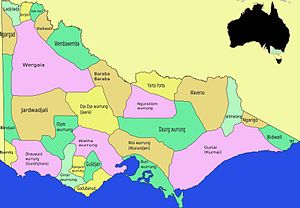
The Djab Wurrung, also spelt Djabwurrung, Tjapwurrung, Tjap Wurrung, or Djapwarrung, people are Aboriginal Australians whose country is the volcanic plains of central Victoria from the Mount William Range of Gariwerd in the west to the Pyrenees range in the east encompassing the Wimmera River flowing north and the headwaters of the Hopkins River flowing south.
There were 41 Djab Wurrung clans who formed an alliance with the neighbouring Jardwadjali people through intermarriage, shared culture, trade and moiety system before colonisation.
The anthropologist Norman Tindale observed that the Djab Wurrung's lands extend over 2,700 square miles (7,000 km2), ranging from Mount Rouse westwards to Hamilton.
[9] At the time of colonisation, the Djab Wurrung language was passed down through fathers, as was an individual clan or local estate group territorial affiliation.
The effect of this has been an increased emphasis on family relationships, broader landscape connections, and a greater significance for senior women in Djab Wurrung and other western Victorian Aboriginal communities.
"[11] Affiliation and co-operation with other western Victorian Aboriginal communities meant that Djab Wurrung people could make the best use of natural resources across the region.
Over 90 per cent of Aboriginal rock art in Victoria can be found on Djab Wurrung and Jardwadjali country, especially in the Grampians National Park.
[13] One of the most significant rock art sites in south-eastern Australia is Bunjil's Shelter on Djab Wurrung country in the Black Range Scenic Reserve, not far from Stawell.
[16] Effective land management and reliable natural resources meant that permanent or semi-permanent villages made up of substantial huts were common on Djab Wurrung country, especially near creeks, streams, and on the verges of swamps.
[18]In 1841, south of Mount William, George Augustus Robinson described seeing many abandoned mounds that were once the base of enclosed huts, which he described as being "large, some 15 feet in diameter."
"[20] The pastoralist Charles Browning Hall wrote in 1853 that About the Grampians [fish weirs] were numerous at the time of my residence, and had apparently been much more so, judging from the traces left by them in the swampy margins of the river.
[19]Clark notes that during early Autumn there were large gatherings of up to 1,000 people for one to two months hosted at the Mount William swamp or at Lake Bolac for the annual eel migration.
Their first explicit contact in the written record was with Major Thomas Mitchell exploring western Victoria in September 1836 when he surprised two women of the Utoul balug and their children near Mount Cole.
In 1842 and 1843 Kolorer was used as a base to launch guerilla attacks against the increasing numbers of squatters and their sheep, then retreat to the reserve which was under the protection of the Assistant Protector of Aborigines, Charles Sievwright.
Ashley Mallett suggests the form played among Wimmera tribes might have been one influence, and cites a passage from the pastoralist and aboriginal rights activist James Dawson on how the Djab Wurrung played the game,[30] using a stitched possum skin for the football: One of the favourite games is football, in which fifty or as many as one hundred players engage at a time.
He was influential later in introducing the "catch" and "kick" style, and in establishing and codifying Australian Rules football,[31] although whether Marn Grook influenced the development of the game is still being debated.
In 1989 there was a proposal by Victorian Minister for Tourism, Steve Crabb to rename many geographical place names associated with Djab Wurrung heritage in the Gariwerd – Grampians National Park area.
[35] The Brambuk National Park and Cultural Centre in Halls Gap is owned and managed by Jardwadjali and Djab Wurrung people from five Aboriginal communities with historic links to the Gariwerd-Grampians ranges and the surrounding plains.
[36] In 2012 Victorian Government road authorities gained statutory approval from Martang, a Registered Aboriginal Party representing Djab Wurrung interests, for upgrade works to the Western Highway.
It was later revealed that the consultation process had been limited, and protesters claimed that many roadside trees along a 12.5 kilometre section of the upgrade from Buangor to Ararat – said to be sacred to Djab Wurrung people – were not set aside for protection during the works.
VicRoads signed the lucrative land deal with the now-defunct Martang Registered Aboriginal Party, which formally approved the highway project in 2013.
Twelve months later, in October 2014, Victoria's roads department gave the authority – all members of one family – hundreds of hectares of land east of the highway, as part of a Trust for Nature covenant.
In return for conserving the site from development, Martang was promised annual royalties amounting to hundreds of thousands of dollars over ten years.
[41] Djab Wurrung woman Sissy Eileen Austin has said that the issue highlights inadequacies in the Victorian Traditional Owner Settlement Act.