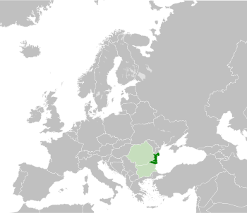
Dobruja
The territory of the Romanian region Dobrogea is organised as the counties of Constanța and Tulcea, with a combined area of 15,588 km2 (6,019 sq mi) and, as of 2021[update], a population of slightly less than 850,000.
[9] Another early use is in the 16th‑century Latin translation of Laonicus Chalcondyles' Histories, where the term Dobroditia is used for the original Greek "Dobrotitsa's country" (Δοβροτίκεω χώρα).
[13] In the 19th century, some authors used the name to refer just to the territory between the southernmost branch of the Danube (St. George) in the north and the Karasu Valley (nowadays the Danube-Black Sea Canal) in the south.
The region had commercial contact with the Mediterranean world by the 14th century BC, as proven by a Mycenaean sword discovered at Medgidia,[16] but under the reserve demanded by lack of hard evidence in what concerns the provenience/manufacturer of such armours.
In the second part of the 8th century BC, the first signs of commercial relations between the indigenous population and the Greeks appeared on the shore of the Halmyris Gulf (now the Sinoe Lake).
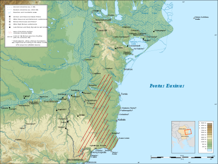
Two Getic tribes, the Crobyzi and Terizi, and the town of Orgame (Argamum) were mentioned on the territory of present Dobruja by Hekataios of Miletus (540–470 BC).
[citation needed] The revolts were suppressed by Lysimachus, the diadochus of Thrace, who also began a military expedition against Dromichaetes, the ruler of the Getae north of the Danube, in 300 BC.
Declared friend and ally of the Roman people by Octavian,[27] Rholes helped Crassus in conquering the states of Dapyx (in central Dobruja) and Zyraxes (in the north of the region).
[28] Dobruja became part of the client kingdom of the Odrysians,[citation needed] while the Greek cities on the coast came under direct rule of the governor of Macedonia.
[citation needed] In 6 AD the Roman province of Moesia was created when mention is made of its governor, Caecina Severus.,[29] but Dobruja, under the name Ripa Thraciae, remained part of the Odrysian kingdom.
[citation needed] The province was generally stable and prosperous until the crisis of the Third Century, which led to the weakening of defences and numerous barbarian invasions.
[32] The results of archaeological research indicate that the Byzantine presence on Dobruja's mainland and the banks of the Danube were reduced at the end of the 6th century, under the pressure of the Migration Period.
In the coastal fortifications on the southern bank of the Danube, the latest Byzantine coin found dates from the time of the emperors Tiberius II Constantine (574–582) and Heraclius (610–641).
[42] According to Barnea, among other historians, during the following three centuries of Bulgarian domination, Byzantines still controlled the Black Sea coast and the mouths of Danube, and for short periods, even some cities.
Khan Omurtag (815–831) built a "glorious home on the Danube" and erected a mound in the middle of the distance between Pliska and his new building, according to his inscription kept in SS.
[47] Many early medieval Bulgar stone inscriptions were found in Dobruja, including historical narratives, inventories of armament or buildings, and commemorative texts.
An old Slavic inscription, found at Mircea Vodă, mentions Zhupan Dimitri (Дѣимитрѣ жѹпанѣ), a local feudal landlord prominent in the south of the region in 943.
[61] In the spring of 1036, an invasion of the Pecheneg devastated large parts of the region,[62] destroying the forts at Capidava and Dervent, and burning the settlement of Dinogeţia.
[68] Around 1263–64, Byzantine Emperor Michael VIII Palaeologus gave permission to Sultan Kaykaus II to settle in the area with a group of Seljuk Turks from Anatolia.
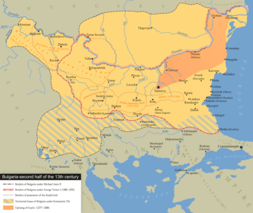
[78] The inability of the Bulgarian authorities to cope with the numerous raids became the main reason for the uprising, led by Ivailo (1277–1280), that broke out in eastern Bulgaria.
[86] In 1347, at John V Palaeologus' request, Emir Bahud-din Umur, Bey of Aydın, led a naval expedition against Balik, destroying Dobruja's seaports.
Dobrotitsa collaborated with the crusaders, and after the allies conquered several Bulgarian forts on the Black Sea, Ivan Alexander freed John and negotiated a peace agreement.
Dobrotitsa's role in this conflict brought him numerous political advantages: his daughter married one of John V's sons, Michael, and his principality extended its control over some of the forts lost by the Bulgarians (Anchialos and Mesembria).
In 1388/1389 Dobruja (Terrae Dobrodicii—as mentioned in a document from 1390) and Dristra (Dârstor) came under the control of Mircea the Elder, ruler of Wallachia, who defeated the Ottoman Grand Vizier.
[92] In 1555, a revolt led by the "false" (düzme) Mustafa, a pretender to the Turkish throne, broke out against Ottoman administration in Rumelia and rapidly spread to Dobruja, but was repressed by the beylerbey of Nigbolu.
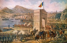
At the advice of the French envoy, a strip of land extended inland from the port of Mangalia (shown orange on the map) was ceded to Romania, since its southwestern corner contained a compact area of ethnic Romanians.
During World War II, Bulgaria regained Southern Dobruja in the September 1940 Axis-sponsored Treaty of Craiova, despite Romanian negotiators' insistence that Balchik and other towns should remain in Romania.
In 1948 and again in 1961–1962, Bulgaria proposed a border rectification in the area of Silistra, consisting mainly of the transfer of a Romanian territory containing the water source of that city.
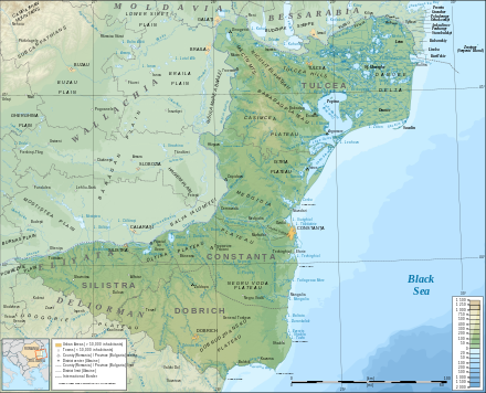
After the Crimean War, a large number of Tatars were forcibly driven away from Crimea, immigrating to then-Ottoman Dobruja and settling mainly in the Karasu Valley in the centre of the region and around Bābā Dāgh.
[106][107] In 1850, the scholar Ion Ionescu de la Brad, wrote in a study on Dobruja, ordered by the Ottoman government, that Bulgarians came to the region "in the last twenty years or so".


.jpg)