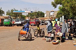
Dogondoutchi
It lies on national route 1 which links the capital to the towns of Maradi and Zinder to the east and the RN25 heading to north to Tahoua, Agadez and Arlit.
[2] The town of Dogondoutchi is dominated to the north by the imposing hill from which it derives its name and it lies along an intermittent river, the Mawri Dallol.
In this sedimentary basin there are extensive sand and clay deposits, the most recent dating from the Tertiary and Quaternary periods.
The rainfall may be very intense – 50, to 150 mm a day, which leads to flash floods causing structural damage to the dry clay (so-called banco) houses along the koris and carrying off arable soil.
Following the catastrophic floods of 2002 the inhabitants, in association with international aide and the United Nations "Food For Work" Programme, constructed five kilometres of dykes which now protect the town.
The Djerma who form the majority of the sedentary population of Niger are mostly settled towards the west whereas Dongondoutchi is the southern limit for the Fula who are pastoralists with semi-nomadic villages.
Dogondoutchi is known as the cultural centre of the Arewa region which roughly corresponds to the birthplace of the Mawari a subgroup of the Hausa.
Most of the births take place in a health centre and this has had a beneficial impact on the mother and child survival rate.
In the villages lying away from the town where the standard of living is lower, family latrines corresponding to the available individual funding have been constructed by the inhabitants themselves.
Prior to this, a programme initiated by USAID was set up to raise awareness concerning hygiene following the CLTS method[13](Community-Led Total Sanitation).
In the zones of economic activity, markets etc., each participating tradesman has (in 2015) the use of two garbage cans, one for biodegradable waste and one for plastics etc.
A joint committee has been set up to monitor this programme and to address the severe problem posed by plastic waste which at present is burnt.
The CREED (Educational Resource and Exchange in Dogondoutchi) opened in 2011 close to the high school and to one of the junior colleges.
It is supported by the State Department of Education through the provision of staff for the library, for the training in information technology and in maintenance.
To encourage literacy and to help with the learning of French, a number of containers each with a hundred or so African books for children funded by the twinned town of Orsay (France)[11] have been distributed in the schools.
[14] This gave rise to a local initiative which was further supported by international funding that increased both agricultural output and revenue.
[11] It was proposed that each farmer reserve part of his land (roughly 1 hectare) for the use of improved seeds together with micro-doses of fertiliser.
Over a three-year period when the rainfall was at a reasonable level, this method led to a 70% increase of production compared to that obtained in the nearby traditionally cultivated field.
The areas concerned occupy about 20 hectares, mostly around the Tapkin Saw lake 1 to 2 km north west of the urban centre and around the village of Liguido.
Traditionally they chiefly produce green vegetables but after the severe drought of 2005, it was suggested that the farmers around the Tapkin Saw diversify their production notably by growing more energy providing crops such as the potato.
To this end the association "Agro Sans Frontières" from Brittany[15] provided the potato seeds without charge and this led to the organisation of a profitable commercial activity.
A technical and hydrological study led to the project for an irrigation system, derived from the deep wells, which covers 80 hectares and which functions throughout the year.
The raising of cattle and goats is usually carried out by the nomadic Fula population, who after the harvest, move southwards to make use of the grazing left in the fields.