Dover Western Heights
[2][3] First given earthworks in 1779 against the planned invasion that year, the high ground west of Dover was properly fortified in 1804 when Lieutenant-Colonel William Twiss was instructed to modernise the existing defences.
[5] The Citadel began as a large bastioned fieldwork, constructed in the early 1780s and containing within its fortifications three loopholed guard houses.
By 1860 the Citadel was entered, via a drawbridge over the ditch, through a gate on the eastern side; a tunnel then led through the rampart into the fort by way of the main guard room.
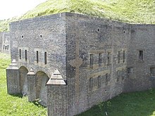
[5] The bomb-proof Officers' Quarters and Mess, built by Major William Jervois in 1860, was designed in part to be able to function as a defensible keep in the event of the Citadel being stormed by the enemy.
[7] After 1890 the Citadel ceased to have a defensive role and functioned instead as a large barracks and mobilisation centre, with additional hut accommodation provided for up to 900 soldiers in total.
[8] In 1956 the Citadel was handed over to HM Prison Service; it served successively as a Borstal, a Youth Custody Centre and a Young Offender Institution.
[10] The rise of Napoleon III during the 1850s caused a further invasion scare, and a Royal Commission was set up in 1859 to investigate the defences of Britain.
Caponiers were added to four of the corners of the existing fort (each with a stone staircase leading up to the top of the Redoubt), and gunrooms were built alongside two of them to allow fire along the North and South-East Lines.
During World War II, the Redoubt housed a squad of commandos that, in the event of invasion, would have been responsible for destroying Dover Harbour.
Evidence of their stay are the sally ports in Caponiers 1 & 2, and the short tunnel leading from the encircling line to Drop Redoubt Road.
[10] In the 1980s, a temporary scaffolding bridge was built by the army to enable access for guided tours of the Redoubt, but this was removed in the middle 1990s to prevent unauthorised entry and vandalism.
The artillery at the Redoubt faced mostly inland; it was intended to attack an invading force attempting to capture Dover from the rear.
[11] During the building of the defensive lines (1809-16) a tiered bulwark, the 'North-West Bastion', was built on the edge of the Citadel flanking the northern slope of the Heights.
Furthermore, the North Entrance was rebuilt and strengthened (necessitated by the rebuilding of the Lines); it was approached by way of a twisting path through the tenaille and lifting and falling bridges across the ditches.
As well as helping protect the Heights from landward attack, the earthworks served to enclose a sizeable area of land (lying between the Citadel and the Redoubt, the North Lines and the escarpments to the south and east.
Access to the terraces was provided by a long flight of steps rising from the far left corner of the parade ground (as viewed from the cliff top).
Between these casemated barracks and the Citadel Road, married quarters and ancillary buildings were provided, on a series of three stepped terraces built into the hillside.
While the married quarters continued to be occupied in the 20th century, by 1912 the casemates were no longer in use as barracks, serving instead as offices for the Royal Garrison Artillery.
[15] To assist with the movement of troops between the Heights and the town defences and harbour, Twiss made his case for building the Grand Shaft in the cliff, adjacent to the barracks parade ground: ‘...the new barracks.....are little more than 300 yards horizontally from the beach.....and about 180 feet (55 m) above high-water mark, but in order to communicate with them from the centre of town, on horseback the distance is nearly a mile and a half and to walk it about three-quarters of a mile, and all the roads unavoidably pass over ground more than 100 feet (30 m) above the barracks, besides the footpaths are so steep and chalky that a number of accidents will unavoidably happen during the wet weather and more especially after floods.
Within ten years, however, construction of the North-East Line of fortification (extending south from the Redoubt) had blocked part of the battery's field of fire.
Local names for the remains of the Pharos are the ‘Bredenstone’ or the ‘Devil’s Drop of Mortar’, and it was here, until 1804, that the Lords Warden of the Cinque Ports had their installation ceremony.