Needles, California
Situated on the western banks of the Colorado River, Needles is located near the California border with Arizona and Nevada.
[7] Needles was founded in May 1883 during the construction of the Atchison, Topeka and Santa Fe Railway,[8] which originally crossed the Colorado River at Eastbridge, Arizona, three miles southeast of modern Needles.
The crossing was a poor site for a bridge, lacking firm banks and a solid bottom.
The railway built Red Rock Bridge, a high cantilever bridge, at a narrower point with solid rock footings, ten miles downstream near today's Topock.
[9]: 82 At first it was a tent town for railroad construction crews, but the railway would eventually build a hotel, car sheds, shops and a roundhouse.
Within only a month, Needles would have a Chinese laundry, a newsstand, a restaurant, several general stores, and nine or ten saloons.
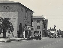
[9]: 82 The railway and the Fred Harvey Company built the elegant Neoclassical and Beaux-Arts style El Garces Hotel and Santa Fe Station in 1908, which was considered the "crown jewel" of the entire Fred Harvey chain.
[10] For migrants from the Midwest Dust Bowl in the 1930s, it was the town that marked their arrival in California.
The "Carty's Camp", which appears briefly in The Grapes of Wrath as the Joad family enters California from Arizona,[8] is now a ghost tourist court, its remains located behind the 1940s-era 66 Motel.
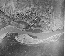
In 1949, the United States Bureau of Reclamation began an extensive project to dredge a new channel for the Colorado River that would straighten out a river bend that caused serious silt problems after the Hoover Dam was completed.
[8] The city is the eastern gateway to the Mojave National Preserve, a scenic desert area.
The Needles weather station is frequently reported by the United States government's National Oceanic and Atmospheric Administration (NOAA) as the site of the highest daily temperature recorded in the U.S. during the desert summers.
[14] On May 4, 2014, Needles reached a temperature of 102 °F (39 °C) with a dewpoint of −38 °F (−39 °C), for a relative humidity of 0.33%, the lowest value ever recorded on Earth.
[16][12] The city is also known for moderate to locally severe thunderstorms during the monsoon season as well as humid conditions.
Major employment in the city is supported by the BNSF Railway (formerly the Santa Fe Railroad).
The depot has been a terminal (crew change point) for the railway since the late 19th century.
According to the United States Census Bureau, the city has a total area of 30.2 square miles (78 km2).
The once smaller nearby communities of Bullhead City, Arizona, Lake Havasu City, Arizona, and Laughlin, Nevada have in recent years become larger communities than Needles.
According to the 2010 United States Census, Needles had a median household income of $29,613, with 28.8% of the population living below the poverty line.
[30] In 2008, claiming the county had been unwilling to help keep the city's troubled hospital open as a full-service medical facility, the city considered seceding from California and becoming part of neighboring Nevada, only a few miles away.
The school district is one of the largest in the United States in terms of area with almost 6,000 square miles (16,000 km2) in its boundaries.
Amtrak, the national passenger rail system, provides daily service to Needles station, operating its Southwest Chief between Chicago and Los Angeles.
[34] As of August 2, 2016, Victor Valley Transit Authority has service from Needles to Barstow and Victorville on Fridays.
[35] On July 1, 2016, San Bernardino County Fire Department annexed the City of Needles.
[36] Fire Station 32 provides fire protection to the City of Needles and houses two Type 1 Engine companies, one Type 7 Engine company, one Water Tender and one 28-foot fireboat.