Draycott and Church Wilne
The main locales are: This is to the centre east of the parish, hemmed in between the Nottingham and Derby railway line to the north and the River Derwent in the south.
Draycott maintains village centre services such as food stores and hospitality, other retail, school and the core housing stock for the area.
The area lies on the banks of the River Derwent and its valley, and is relatively flat, the land rising gradually to the north of the parish, with no hills.
[5] A related piece of infrastructure which runs alongside this, the Leicester branch of the Upper Derwent Valley aqueduct, does however come through the north east of the Draycott and Church Wilne parish.
The highest section is adjacent to the far north parish boundary, within an area hemmed in by the B5010 and A52 roads by the Hill Top farm at 75 metres (246 ft).
[7] By the time of the Domesday survey in 1086, the area was part of Morlestan wapentake, and associated to Sawley, which became an extensive parish containing the chapelries of Wilne, Long-Eaton, Breason, Risley and the hamlets of Draycott and Hopwell.
[15] Domesday records: "in Salle, and Dracot, and Opeuuelle (Hopwell), a priest and two churches, a mill, one fishery, and thirty acres of meadow.
[22] It is possible water level issues throughout the Derwent floodplain probably began an exodus of locals towards slightly higher ground alongside a key transportation route, the Roman road.
[13] Some early topographic, documentary, cartographic and excavation evidence shows Wilne church may have been enclosed on as many as three sides by medieval meanders of the Derwent.
[8] The ownership of the Sawley/Draycott/Church Wilne manors stayed with the diocese for some centuries, and after the Dissolution of the monasteries it was leased to the Stanhope family by the 1540s, of which the Earl of Harrington was their later peerage.
The Market Place was a key stopover point where donkeys were changed over and is the origin of the nickname as the term 'neddy' is in informal usage within some parts of England but was also applied at Draycott.
[31] The relocation of locals increased into the 18th and 19th centuries as Victorian infrastructure such as roads, canals, railways, electricity and industry were brought to Draycott.
It was a cotton 'twist' mill from the 1820s or earlier which is thought to have failed early on and was later sold to a local co-operative society and converted to dwellings and used into the 20th century.
[3] The area became a key centre for lace when Nottingham’s manufacturers began looking outside the city for cheaper labour in nearby towns and villages, towards the end of the 19th century in Draycott wages were half those.
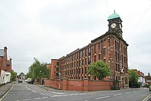
A new mill using a novel way of hiring out not just space but also individual weaving machines[46] was being built with Ernest Terah Hooley as an early investor and Ernest Jardine as eventual owner, and named to commemorate Queen Victoria’s 1887 Golden Jubilee, however a fire devastated the progress made and delayed building such that, when Victoria Mill was completed 19 years later in 1907, Edward VII had been on the throne for six years.
There is also Ambaston Ford which is at the end of a path leading from Nooning Lane, which is still indicated with depth poles so possibly passable at very low river levels.
Formal parish council reports were that it was withdrawn from service by the Air Ministry during the Second World War for security purposes, although an alternative legend is that the boat was stolen in the 1950s.
[53][54] Attewell House on Station Road was home to Marcus Astle, proprietor of Wilne Mills, it was constructed in the late 19th century.
This remained the only worship place through the countrywide late medieval Protestantism and non-conformist movements until 1800 when the Wesleyan Methodists opened a branch on Lodge Street.
St. Mary was initially opened as a chapel of ease to St Chads in 1928 on Garfield Avenue,[56][58] and presumably having outgrown the premises, moved into the unused Wesleyan building in 1967,[59] with their original site becoming the present-day local Scouts group headquarters.
[74] Draycott Mill while mainly hosting cotton and lace manufacturers, part of the premises was known to be occupied by bicycle component makers from the late 1800s.
The original factory front on Market Street was in 2001 converted to housing, the units in the rear of the site still involved with varied industrial and commercial uses.
[76][77][78] At Wilne, the mill buildings there continued to be worked by the Astle family until the late 1940s when the site was sold in 1949 to Haley and Weller, a toy company specialising in fireworks.
It struggled through the first half of the 20th century before being closed in 1964 and parts of its route outside the parish built over to accommodate road schemes such as the M1 motorway at Breaston/Long Eaton and the A52 interchange at Derby.
[81] The last houses in Church Wilne were demolished in the 1960s, likely due to wider land being obtained for quarrying, and only two cottages next to the Coffin Walk are presently in the vicinity.
[18][19] After the completion of the extraction works, the parish council obtained the land adjacent to the Wilne church from the quarry firm for a token one pound in 1984.
Needing a permanent base, in 1999 organisers discovered the boxing gym building was a suitable location and hired out space, eventually taking over the lease, renovating and the enlarging the building as they grew in membership and notability, eventually renaming themselves The Draycott & Long Eaton Table Tennis Club as a nod to former and present links with the communities.
Facilities include:[13] Millennium Green (left of Hopwell Road) Draycott Playing Fields (right of Hopwell Road) The Leisure Green (New Street) St Chad's Nature Reserve (Church Wilne) The Midshires Way is a long-distance footpath and bridleway that runs for 230 miles (370 km) from the Chiltern Hills from Buckinghamshire to Greater Manchester.
[13] There are two monument items throughout the parish commemorating local personnel who served in the World War I and WWII conflicts: A memorial cross by the roadside at Draycott village[102] A WWII war memorial for a Royal Air Force member consisting of figures and a plaque in St Chad's Church[103] Only Draycott is catered to with public transport services.
It is a scheduled route, with buses on half hour intervals on weekdays and Saturdays, with some longer periods between services on Sundays and bank holidays.