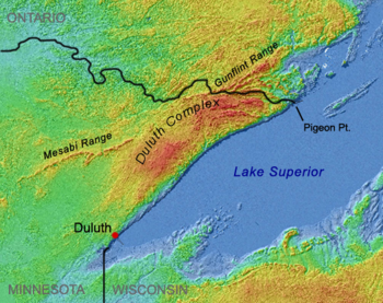
Duluth Complex
Near Lake Superior these intrusive formations intermingle in a complex mosaic with the rocks of the associated North Shore Volcanics, which also are relics of the Midcontinent rifting event.
The North Shore Volcanics originated c. 1109-1096 mya[11] from hundreds of individual lava flows, forming six distinct tilted and partially stacked plateaus which total more than 8,000 meters in thickness.
[20][21][22] Along its northern margin, the Duluth Complex adjoins older structures, the Archaen Ely Greenstones (once believed to be the oldest exposed rock on earth),[23] and the ore-bearing Mesabi and Gunflint iron ranges deposited as part of the Animikie Group from the Penokean orogeny, a mountain-building event from Paleoproterozoic times.
[28] The Duluth Complex was considered to be a giant lopolith, a lens-shaped structure depressed in the center, connecting gabbro exposures on opposite sides of the lake,[29] but now is recognized to extend only a few kilometers south of Superior's North Shore.
[30] The Precambrian bedrock of the Duluth Complex and the North Shore Volcanics is close to or at the surface and not buried beneath layers of later sedimentary rock as is common further south.
Glaciers scoured away earlier soils, and as is typical of the Canadian Shield, the new topsoils are thin and poor, being derived from the rock beneath or nearby rather than from deep layers of glacial till, which is intermittent and relatively shallow over most of the region.
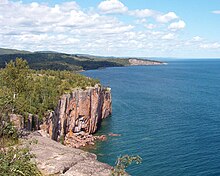
In between, Superior's shoreline from Duluth to the international border has been likened to one long volcanic outcrop,[35] albeit interrupted by parts of the Beaver Bay Complex, such as the anorthosite cliffs at Split Rock Lighthouse adjacent to basalt flows.
[36] Prominent relics of volcanism include rhyolitic cliffs at Palisade Head, basaltic lava flows at Gooseberry Falls, and the Sawtooth Mountains further east.
[27] Most of the eastern part of the Superior National Forest and its Boundary Waters Canoe Area Wilderness (BWCAW) is located on the Duluth Complex, and its exposed Late Precambrian bedrock formations are characteristic features of the region.