Dunhuang
[3] Sachu (Dunhuang) was a major stop on the ancient Silk Road and is best known for the nearby Mogao Caves.
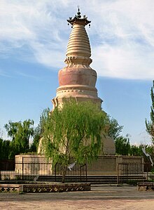
Dunhuang is situated in an oasis containing Crescent Lake and Mingsha Shan (鳴沙山, meaning "Singing-Sand Mountain"), named after the sound of the wind whipping off the dunes, the singing sand phenomenon.
Dunhuang commands a strategic position at the crossroads of the ancient Southern Silk Route and the main road leading from India via Lhasa to Mongolia and southern Siberia,[4] and also controls the entrance to the narrow Hexi Corridor, which leads straight to the heart of the north Chinese plains and the ancient capitals of Chang'an (today known as Xi'an) and Luoyang.
A number of derivations of the name Dunhuang have been suggested by scholars:[citation needed] There is evidence of habitation in the area as early as 2,000 BC, possibly by people recorded as the Qiang in Chinese history.
According to Zuo Zhuan and Book of the Later Han, the Dunhuang region was a part of the ancient Guazhou, which was known for its production of melons.
Some have argued that this may refer to the unrelated toponym Dunhong – the archaeologist Lin Meicun has also suggested that Dunhuan may be a Chinese name for the Tukhara, a people widely believed to be a Central Asian offshoot of the Yuezhi.
[9] Located in the western end of the Hexi Corridor near the historic junction of the Northern and Southern Silk Roads, Dunhuang was a town of military importance.
[10]"The Great Wall was extended to Dunhuang, and a line of fortified beacon towers stretched westwards into the desert.
By the second century AD Dunhuang had a population of more than 76,000 and was a key supply base for caravans that passed through the city: those setting out for the arduous trek across the desert loaded up with water and food supplies, and others arriving from the west gratefully looked upon the mirage-like sight of Dunhuang's walls, which signified safety and comfort.
"[11]During the Sui (581–618) and Tang (618–907) dynasties, it was the main stop of communication between ancient China and the rest of the world and a major hub of commerce of the Silk Road.
Dunhuang was the intersection city of all three main silk routes (north, central, south) during this time.
"[12] A number of Christian, Jewish, and Manichaean artifacts have also been found in the caves (see for example Jingjiao Documents), testimony to the wide variety of people who made their way along the Silk Road.
[13] From the reconquest of 848 to about 1036 (i.e. era of the Guiyi Circuit), Dunhuang was a multicultural entrepot that contained one of the largest ethnic Sogdian communities in China following the An Lushan Rebellion.
Dunhuang went into a steep decline after the Chinese trade with the outside world became dominated by southern sea-routes, and the Silk Road was officially abandoned during the Ming dynasty.
[18] The spreading Kumtag Desert, the result of long-standing overgrazing of the surrounding land, has reached the edges of the city.
[19] In 2011 satellite images showing huge structures in the desert near Dunhuang surfaced online and caused a brief media stir.
Discoveries continue to be found in the caves, including excerpts from a Christian Bible dating to the Yuan dynasty.
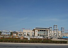
[29] The city's sole other township-level division is Qinghai Petroleum Authority Life Base [zh].