Dzungaria
Dzungaria is Xinjiang's center of heavy industry, generates most of the region's GDP, and houses its political capital Ürümqi (Oirat for 'beautiful pasture').
[9][10] One of the earliest mentions of the Dzungaria region occurs when the Han dynasty dispatched an explorer to investigate lands to the west, using the northernmost Silk Road trackway of about 2,600 kilometres (1,600 mi) in length, which connected the ancient Chinese capital of Xi'an to the west over the Wushao Ling Pass to Wuwei and emerged in Kashgar.
[11] Istämi of the Göktürks received the lands of Dzungaria as an inheritance after the death of his father in the latter half of the sixth century AD.
[12] Dzungar power reached its height in the second half of the 17th century, when Galdan Boshugtu Khan repeatedly intervened in the affairs of the Kazakhs to the west, but it was completely destroyed by the Qing Empire about 1757–1759.
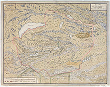
Its widest limit included Kashgar, Yarkand, Khotan, the whole region of the Tian Shan, and the greater proportion of that part of Central Asia which extends from 35° to 50° N and from 72° to 97° E.[8] After 1761, its territory fell mostly to the Qing dynasty during the campaign against the Dzungars (Xinjiang and north-western Mongolia) and partly to Russian Turkestan (the earlier Kazakh state provinces of Zhetysu and Irtysh river).
After the Dzungar genocide, the Qing subsequently began to repopulate the area with Han and Hui people from China proper.
Since 1953, northern Xinjiang has attracted skilled workers from all over China—who have mostly been Han Chinese—to work on water conservation and industrial projects, especially the Karamay oil fields.
Intraprovincial migration has mostly been directed towards Dzungaria also, with immigrants from the poor Uyghur areas of southern Xinjiang flooding to the provincial capital of Ürümqi to find work.
[citation needed] As a political or geographical term, Dzungaria has practically disappeared from the map; but the range of mountains stretching north-east along the southern frontier of the Zhetysu, as the district to the southeast of Lake Balkhash preserves the name of Dzungarian Alatau.
Wheat, barley, oats, and sugar beets are grown, and cattle, sheep, and horses are raised in Dzungaria.
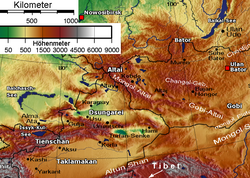
The western corner is the Dzungarian Gate, a historically important gateway between Dzungaria and the Kazakh Steppe; presently, a highway and a railway (opened in 1990) run through it, connecting China with Kazakhstan.
In the southwest, the tall Borohoro Mountains branch of the Tian Shan separates the basin from the upper Ili River.
[15] It is a largely steppe and semi-desert basin surrounded by high mountains: the Tian Shan (ancient Mount Imeon) in the south and the Altai in the north.
Streams descending from the Tian Shan and Altai ranges support stands of poplar (Populus diversifolia) together with Nitraria roborovsky, N. sibirica, Neotrinia splendens, tamarisk (Tamarix sibirimosissima), and willow (Salix ledebouriana).
The northeastern portion of the Dzungarian Basin semi-desert lies within Great Gobi National Park, and is home to herds of Onagers (Equus hemionus), goitered gazelles (Gazella subgutturosa) and Wild Bactrian camels (Camelus ferus).
Dzungaria and its derivatives are used to name a number of pre-historic animals,[19] hailing from the rocky outcrops located in the Dzungar Basin: A notable find, in February 2006, is the oldest tyrannosaur fossil unearthed by a team of scientists from George Washington University who were conducting a study in the Dzungarian Basin.