ESTCube-1
[5] The CubeSat standard for nanosatellites was followed during the engineering of ESTCube-1, resulting in a 10×10×11.35 cm cube, with a volume of 1 liter and a mass of 1.048 kg.
[6][7] The mission ended officially on 17 February, 2015, and it was said that during this time it resulted in 29 bachelor's and 19 master's dissertations, 5 doctoral theses and 4 start-ups.
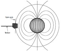
The satellite carried an electric solar wind sail (E-sail), which was invented by Finnish scientist, Pekka Janhunen.
[12] To control the E-sail element's interaction with both the plasma surrounding the Earth and the effect it had on the spacecraft's spinning speed, two nanotechnology electron emitters/guns were on board.
The positive ions in the plasma were intended to push the E-sail element and influence the satellite's rotation speed.
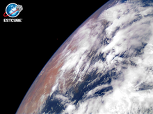
The satellite was placed into orbit and communication successfully established,[13] with the first photo of the Earth taken on May 15, and transmitted to the ground on the amateur radio band.
[5] The plan, beginning with the 7 May 2013 launch, included the following steps: The mission ended due to degradation of the photovoltaic power system[1] and subsequently the batteries became exhausted.
The last official transmission was transmitted on 17 February, 2015, however, imaging the Earth and gathering environmental data continued till May 19, 2015.