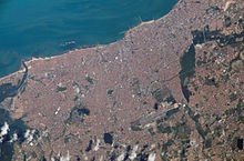
Satellite imagery
Less mainstream uses include anomaly hunting, a criticized investigation technique involving the search of satellite images for unexplained phenomena.
In addition to the satellite applications mentioned above, these data can serve as powerful educational tools, advance scientific research and promote a deeper understanding of our environment.
There are five types of resolution when discussing satellite imagery in remote sensing: spatial, spectral, temporal, radiometric and geometric.
For example, the Landsat archive offers repeated imagery at 30 meter resolution for the planet, but most of it has not been processed from the raw data.
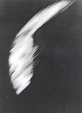
The CORONA program was a series of American strategic reconnaissance satellites produced and operated by the Central Intelligence Agency (CIA) Directorate of Science & Technology with substantial assistance from the U.S. Air Force.
Beginning with Landsat 5, thermal infrared imagery was also collected (at coarser spatial resolution than the optical data).
The ASTER is an imaging instrument onboard Terra, the flagship satellite of NASA's Earth Observing System (EOS) launched in December 1999.
The Himawari satellite series represents a significant leap forward in meteorological observation and environmental monitoring.
With their advanced imaging technology and frequent data updates, Himawari-8 and Himawari-9 have become indispensable tools for weather forecasting, disaster management, and climate research, benefiting not only Japan but the entire Asia-Pacific region.
[10] The 0.46 meters resolution of WorldView-2's panchromatic images allows the satellite to distinguish between objects on the ground that are at least 46 cm apart.
Similarly Maxar's QuickBird satellite provides 0.6 meter resolution (at nadir) panchromatic images.
[11] Pléiades constellation is composed of two very-high-resolution (50 centimeters pan & 2.1 meter spectral) optical Earth-imaging satellites.
Designed as a dual civil/military system, Pléiades will meet the space imagery requirements of European defense as well as civil and commercial needs.
Pléiades Neo [fr][12] is the advanced optical constellation, with four identical 30-cm resolution satellites with fast reactivity.
RapidEye satellite imagery is especially suited for agricultural, environmental, cartographic and disaster management applications.
[15][16] SkySat is a constellation of sub-metre resolution Earth observation satellites that provide imagery, high-definition video and analytics services.
[17] Planet acquired the satellites with their purchase of Terra Bella (formerly Skybox Imaging), a Mountain View, California-based company founded in 2009 by Dan Berkenstock, Julian Mann, John Fenwick, and Ching-Yu Hu,[18] from Google in 2017.
[19] The SkySat satellites are based on using inexpensive automotive grade electronics and fast commercially available processors,[20] but scaled up to approximately the size of a minifridge.
EROS satellites imagery applications are primarily for intelligence, homeland security and national development purposes but also employed in a wide range of civilian applications, including: mapping, border control, infrastructure planning, agricultural monitoring, environmental monitoring, disaster response, training and simulations, etc.
GaoJing-1 / SuperView-1 (01, 02, 03, 04) is a commercial constellation of Chinese remote sensing satellites controlled by China Siwei Surveying and Mapping Technology Co. Ltd.
For such reasons, publicly available satellite image datasets are typically processed for visual or scientific commercial use by third parties.