East Anglia
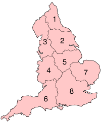
The modern NUTS 2 statistical unit of East Anglia comprises Norfolk, Suffolk and Cambridgeshire (including the City of Peterborough unitary authority).
[1] Those three counties have formed the Roman Catholic Diocese of East Anglia since 1976, and were the subject of a possible government devolution package in 2016.
Culturally, north Essex has much more in common with Suffolk and the rest of East Anglia due to its similar rural landscape, when compared to the south which is much more urban given its proximity to London.
The proposed East Anglia province would have included northern Essex, southern Lincolnshire and a small part of Northamptonshire as well as Cambridgeshire, Norfolk and Suffolk.
It was formed around 520 by merging the North and South Folk, Angles who had settled in the former lands of the Iceni during the previous century, and it was one of the Anglo-Saxon heptarchy kingdoms as defined in the 12th-century writings of Henry of Huntingdon.
[8][page needed] East Anglia has been cited by a number of scholars as being a region where settlement of continental Germanic speakers was particularly early and dense,[9][10][11] possibly following a depopulation in the 4th century.
Parts of East Anglia remained marshland until the 17th-century drainage of the Fens, despite some earlier engineering work during the Roman occupation.
[16][page needed] East Anglia based much of its earnings on wool, textiles, and arable farming and was a rich area of England until the Industrial Revolution caused a manufacturing and development shift to the Midlands and the North.
East Anglia was ideally suited to airfield construction, as it includes large areas of open, level terrain and is close to mainland Europe.
Much of northern East Anglia is flat, low-lying and marshy (such as the Fens of Cambridgeshire and Norfolk), although the extensive drainage projects of the past centuries actually make this one of the driest areas in the UK.
Conversely, over to the east on the coast exposed to the North Sea the coastline is subject to rapid erosion and has shifted inland significantly since historic times.
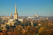
Major urban areas in East Anglia include the cities of Norwich, Cambridge and Peterborough, and the town of Ipswich.
Other towns and cities include Bury St Edmunds, Ely, Lowestoft, Great Yarmouth, King's Lynn, and Newmarket.
Although water plays a significant role in the Fenland and Broadland landscapes, the area is among the driest in the United Kingdom and during the summer months, tinder-dry conditions are frequently experienced, occasionally resulting in field and heath fires.
The coat of arms was ascribed by medieval heralds to the Anglo-Saxon Kingdom of East Anglia and the Wuffingas dynasty which ruled it.
Other users of the arms include the former Isle of Ely County Council, the Borough of Colchester and the University of East Anglia.
East Anglia features heavily in English literature, notably in Noël Coward's Private Lives and the history of its waterways and drainage forms the backdrop to Graham Swift's novel Waterland.
Other tourist attractions include historic towns and cities like Bury St Edmunds, Cambridge and Ely as well as areas such as Constable Country, the Broads and the North Norfolk coast.