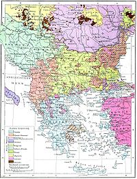
Eastern Rumelia
Some twenty Pomak (Bulgarian Muslim) villages in the Rhodope Mountains refused to recognize Eastern Rumelian authority and formed the so-called Republic of Tamrash.
According to the Treaty of Berlin, Eastern Rumelia was to remain under the political and military jurisdiction of the Ottoman Empire with significant administrative autonomy (Article 13).
The law frame of Eastern Rumelia was defined with the Organic Statute which was adopted on 14 April 1879 and was in force until the Unification with Bulgaria in 1885.
[8] According to the Organic Statute the head of the province was a Christian Governor-General appointed by the Sublime Porte with the approval of the Great Powers.
Eastern Rumelia consisted of the departments (called in Bulgarian окръзи okrazi, in Ottoman terminology sanjaks) of Plovdiv (Пловдив, Filibe), Tatarpazardzhik (Татарпазарджик, Tatarpazarcığı), Haskovo (Хасково, Hasköy), Stara Zagora (Стара Загора, Eski Zağra), Sliven (Сливен, İslimye) and Burgas (Бургас, Burgaz), in turn divided into 28 cantons (equivalent to Bulgarian околии okolii, Ottoman kazas).
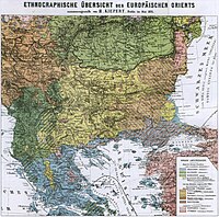
In the discredited[16] census of 1880, out of total population of 815,951 people some 590,000 (72.3%) self-identified as Bulgarians, 158,000 (19.4%) as Turks, 19,500 (2.4%) as Roma, and 48,000 (5.9%) belonged to other ethnicities,[17] notably Greeks, Armenians and Jews.
Eastern Rumelia was also inhabited by foreign nationals, most notably Austrians, Czechs, Hungarians, French people and Italians.
Those Turkish landowners who were not able to take possession of their land were financially compensated, with the funds collected by the Bulgarian peasants, some of whom were indebted as a result.
[21][22] Michael Palairet claimed that land rights of Muslim owners were largely disregarded, despite being guaranteed by the great powers, and the de-Ottomanization of Bulgaria and Eastern Rumelia led to economic decline in the region.