Moai
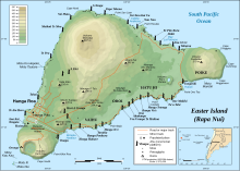
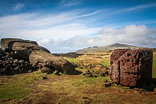
[1][2] Nearly half are still at Rano Raraku, the main moai quarry, but hundreds were transported from there and set on stone platforms called ahu around the island's perimeter.
[3] The statues still gazed inland across their clan lands when Europeans first visited the island in 1722, but all of them had fallen by the latter part of the 19th century.
[4] The moai were toppled in the late 18th and early 19th centuries, possibly as a result of European contact or internecine tribal wars.
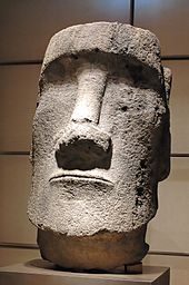
Easter Island statues are known for their large, broad noses and big chins, along with rectangle-shaped ears and deep eye slits.
Carved stone and wooden objects in ancient Polynesian religions, when properly fashioned and ritually prepared, were believed to be charged by a magical spiritual essence called mana.
[20] A study in 2019 concluded that ancient people believed that quarrying of the moai might be related to improving soil fertility and thereby critical food supplies.
The Routledge expedition of 1914 established a cultural link[23] between these designs and the island's traditional tattooing, which had been repressed by missionaries a half-century earlier.
Until modern DNA analysis of the islanders and their ancestors, this was key scientific evidence that the moai had been carved by the Rapa Nui and not by a separate group from South America.
[1] In addition to representing deceased ancestors, the moai, once they were erected on ahu, may also have been regarded as the embodiment of powerful living or former chiefs and important lineage status symbols.
Moai must have been very time-consuming to craft and transport; not only would the actual carving of each statue require effort and resources, but the finished product was then hauled to its final location and erected.
In the nineteenth century, this led to conjecture that the island was the remnant of a sunken continent and that most completed moai were under the sea.
The earliest accounts say a king named Tuu Ku Ihu moved them with the help of the god Makemake, while later stories tell of a woman who lived alone on the mountain ordering them about at her will.
Scholars currently support the theory that the main method was that the moai were "walked" upright (some assume by a rocking process), as laying it prone on a sledge (the method used by the Easter Islanders to move stone in the 1860s) would have required an estimated 1500 people to move the largest moai that had been successfully erected.
In 1998, Jo Anne Van Tilburg suggested fewer than half that number could do it by placing the sledge on lubricated rollers.
A replica was loaded on a sledge built in the shape of an A frame that was placed on rollers and 60 people pulled on several ropes in two attempts to tow the moai.
Despite the early end to the experiment, Thor Heyerdahl estimated that this method for a 20-tonne statue over Easter Island terrain would allow 320 feet (100 m) per day.
[4] Hunt and Lipo argue that when the statues were carved at a quarry, the sculptors left their bases wide and curved along the front edge.
[citation needed] Through the years the power levels veered from sole chiefs to a warrior class known as matatoʻa.
The therianthropic figure of a half bird and half-man was the symbol of the matatoʻa; the distinct character connected the sacred site of Orongo.
"[41] Orongo, the site of the cult's festivities, was a dangerous landscape which consisted of a "narrow ridge between a 1,000-foot (300 m) drop into the ocean on one side and a deep crater on the other".
Considered the sacred spot of Orongo, Mata Ngarau was the location where birdman priests prayed and chanted for a successful egg hunt.
Contestants descended the sheer cliffs of Orongo and swam to Motu Nui where they awaited the coming of the birds.
Having procured an egg, the contestant swam back and presented it to his sponsor, who then was declared birdman for that year, an important status position.
[43] In years after the arrival in 1722 of Jacob Roggeveen, all of the moai that had been erected on ahu were toppled; some last standing statues were reported in 1838 by Abel Aubert du Petit-Thouars, but none remained by 1868,[44] apart from the partially buried ones on the outer slopes of Rano Raraku.
Oral histories include an account of a clan pushing down a single moai in the night, but others tell of the "earth shaking", and there are indications that at least some of them fell down due to earthquakes.
[49] From 1955 to 1978, an American archaeologist, William Mulloy, undertook extensive investigation of the production, transportation and erection of Easter Island's monumental statuary.
[50] The statues have been mapped by a number of groups over the years, including efforts by Father Sebastian Englert and Chilean researchers.
[51][52] The EISP (Easter Island Statue Project) conducted research and documentation on many of the moai on Rapa Nui and the artifacts held in museums overseas.
The purpose of the project is to understand the figures original use, context, and meaning, with the results being provided to the Rapa Nui families and the island's public agencies that are responsible for conservation and preservation of the moai.
[63] Notwithstanding its intended purpose, the emoji is commonly used in Internet culture as a meme to represent a deadpan expression or used to convey that something is being said in a particularly sarcastic fashion.