Eastern Parkway
The road begins at Grand Army Plaza (the main entrance to Prospect Park) and runs 3.8 miles (6.1 km) east to Bushwick Avenue.
the thoroughfare consists of a broad, bidirectional avenue of six lanes, separated by a median from a narrow parallel service road on the north side.
[12] There have historically been tensions between the two demographic groups,[13] especially after the 1991 Crown Heights riot, which occurred after one of the cars in Chabad-Lubavitch Rebbe Menachem Mendel Schneerson's motorcade struck two Guyanese children.
[16] One news reporter wrote in the 1990s that, although Eastern Parkway's apartment buildings and rowhouses were typical of a mid-20th-century American middle-class neighborhood, its West Indian and Jewish populations "created a world that sometimes resembles two vastly different countries".
[38] Commercial vehicles are prohibited on all three roadways west of Ralph Avenue, since that section of Eastern Parkway is classified as part of the New York City parks system.
[45] Furthermore, drivers frequently exceed the speed limit of 25 miles per hour (40 km/h) due to the design of the main road, which is long, wide, and straight.
[56] In addition, dedicated turn lanes were added, and traffic signal phases were modified so cars did not conflict with pedestrians and cyclists.
[6] Approximately 17,000 years ago, the moraine of the receding Wisconsin Glacier, which formed Long Island, established a string of hills.
[65] On May 6, 1868, the New York State Legislature approved the widening of the right-of-way between Washington and Ralph avenues, the latter street being the boundary of the City of Brooklyn at the time.
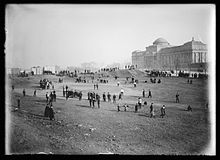
[72] At the time of its completion, Eastern Parkway overlooked the then-separate city of New York to the north, as well as Coney Island and the Rockaways to the south.
[79] Development was also hindered by the presence of the Kings County Penitentiary near Nostrand Avenue, as well as stables, pig farms, and dumps along the parkway.
[80] The Brooklyn city government had placed a tax assessment on nearby properties to fund the parkway's construction, but many smaller landowners instead abandoned their land.
[5][85] The Brooklyn Daily Eagle described the Ralph Avenue terminus in 1896 as being situated "on the brow of a forbidding hill",[86] and the New-York Tribune wrote in 1894 that the parkway had "not more than half a dozen recently built houses".
[93][94] During the 1890s, the Brooklyn park commissioners proposed widening the service roads by 10 feet (3.0 m) to accommodate heavy vehicles,[95][96] as well as repaving the entire roadway.
[81] State lawmakers introduced legislation to extend the parkway in March 1891;[112][113] the Assembly passed the bill at the end of that month,[114] and the Senate approved it that April.
[141] Workers renovated Eastern Parkway during 1900,[142][143] and New York City park commissioners decreed the same year that heavy wagons use the service roads instead of the main roadway.
[6][155] Eastern Parkway divided the Crow Hill section of Crown Heights to the south and the African American village of Weeksville to the north.
[158] As part of the Dual Contracts, in 1914 the Interborough Rapid Transit Company (IRT) agreed to extend its Brooklyn Line under Flatbush Avenue and Eastern Parkway.
[166] The four-track tunnel under Eastern Parkway was built as a double-decked structure, except at the Franklin Avenue station, where all tracks were on the same level.
[167] The tunnel between Grand Army Plaza and Nostrand Avenue was built using the cut-and-cover method, with two steam shovels excavating an estimated 600,000 cubic yards (460,000 m3).
[80] After the subway opened, large numbers of Jews and African-Americans moved into high-rise buildings along Eastern Parkway, such as Copley Plaza and Turner Towers.
[178][179] The Slocum statue at the intersection with Bedford Avenue, which posed a danger to the increasing automobile traffic on the parkway,[180][181] was relocated to Prospect Park in 1924.
[181][183] Following requests from local politicians,[184][185] the city government agreed to install additional traffic lights on the western section of the parkway in 1927.
[195] To direct motorists to the 1939 New York World's Fair in Queens, the city government installed amber-colored street lamps on the parkway east of Howard Avenue.
[204] Accordingly, the New York City Department of Transportation (NYCDOT) announced in 1958 that it would add yield signs and traffic lights to Eastern Parkway's service roads at several intersections.
[31] According to Leone, the city-landmark designation would allow the city government to more easily apply for state and federal funding to rebuild Eastern Parkway.
[233] Granite curbs were installed; benches, street lights, and traffic signs were replaced; and a bike lane with hexagonal asphalt blocks was added.
[234][235] Due to a dispute with the New York City government, Naclerio temporarily halted work on the reconstruction of Eastern Parkway from 1988 to September 1989.
[52] As part of a pilot program, the NYCDOT also replaced the parkway's street lamps with LED lights in the early 2010s, a move that saved $70,000 annually.
[30][266][267] The East New York Savings Bank Building, a designated city landmark, is at 1117 Eastern Parkway on the northwest corner with Utica Avenue.