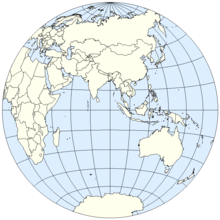
Eastern Hemisphere
It is also used to refer to Afro-Eurasia (Africa and Eurasia) and Australia, in contrast with the Western Hemisphere, which includes mainly North and South America.
The almost perfect circle (the earth is an oblate spheroid that is wider around the equator), drawn with a line, demarcating the Eastern and Western Hemispheres must be an arbitrarily decided and published convention, unlike the equator (an imaginary line encircling Earth, equidistant from its poles), which divides the Northern and Southern hemispheres.
This convention was established in 1884 at the International Meridian Conference held in Washington, D.C. where the standard time concepts of Canadian railroad engineer Sir Sandford Fleming were adopted.
Consequently, meridians of 20°W and the diametrically opposed 160°E are often used outside of matters of physics and navigation,[1][2] which includes all of the European and African mainlands, but also includes a small portion of northeast Greenland (typically reckoned as part of North America) and excludes more of eastern Russia and Oceania (e.g., New Zealand).
Below is a list of the sovereign states in both the Western and Eastern hemispheres on the IERS Reference Meridian, in order from north to south: Below is a list of additional sovereign states which are in both the Western and Eastern hemispheres along the 180th meridian, in order from north to south.