Edwards Aquifer
Located in South Central Texas, the Edwards Aquifer encompasses an area of approximately 4,350 square miles (11,300 km2) that extends into parts of 11 counties.
[4] The aquifer is hydrologically separated into the Austin and San Antonio regions by a groundwater divide near the town of Kyle in Hays County.
The Maverick Basin portion of the Edwards Aquifer consists of the West Nueces, McKnight, and Salmon Peak Formations.
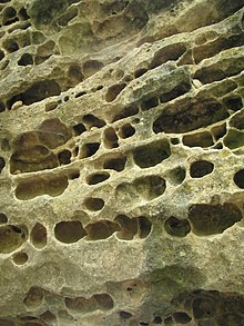
[11] The Edwards limestone is variable in hydrologic character, but is generally highly porous and permeable, which makes it able to hold and move a lot of water.
[15] The proximity of the Edwards Plateau to the Gulf of Mexico and its location in the middle latitudes creates variation in the weather patterns experienced between different years, seasons, and months.
On a yearly basis, ions, metals, nutrients, bacteria, pesticides, VOCs, and synthesized chemicals remained below the EPA's published Maximum Contaminant Levels (MCLs).
[23] Anthropogenically sourced pollutants (pesticides, VOCs, and synthetically derived compounds) can be found within the Edwards Aquifer at minuscule levels.
[24] The widemouth blindcat (Satan eurystomus),[24] a unique species of blind catfish, has been pumped out of wells almost 610 meters deep along the FW-SW boundary.
[31] This is due in part to the constant nature of the temperature and flow of the aquifer waters that have created unique ecosystems supporting a high degree of endemism.
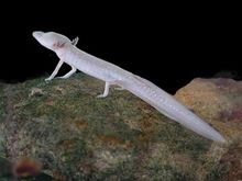
[32] The Edwards Aquifer is the sole environment for the rare Barton Springs salamander (Eurycea sosorum), which is a federally listed endangered species.
The San Marcos gambusia (Gambusia georgei), Texas wild rice (Zizania texana), fountain darter (Etheostoma fonticola), Texas blind salamander (Typhlomolge rathbuni), Comal Springs riffle beetle (Heterelmis comalensis), Comal Springs dryopid beetle (Stygoparnus comalensis), and Peck's cave amphipod (Stygobromus pecki) are listed as endangered.
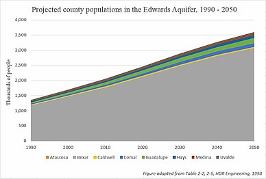
In 2012, the US Census Bureau noted four counties located within the Edwards Region; Kendal, Comal, Hays and Travis were among the fastest growing in the nation, all with growth rates between 25 and 50 percent.
In an effort to preserve undeveloped land the city of San Antonio passed the Edwards Aquifer Protection Plan in 2000 (renewed in 2005, 2010 and 2015).
[42] South Texas is regionally defined by recent economic growth in shipping industries, irrigation based farming, and manufacturing.
[44] Additionally, irrigated agriculture is a significant user of the Edwards Aquifer groundwater, with a variety of crops cultivated, including: " vegetables, hay sesame, soybeans, peanuts, cotton, corn, sorghum, wheat, and oats".
[53][54] Additionally, federal entities including US Geological Survey, US Fish and Wildlife Service, and US Environmental Protection Agency have been involved in water steward activities and recovery management plans of the Edwards aquifer system.
Springs fed by the aquifer played a key role in deciding the location of the Alamo mission and other settlements in the Texas Hill Country.
Starting in the 1970s, the Texas Water Quality Board (TWQB) first recognized the aquifer and issued regulations regarding surface recharge zones.
[58] In 1992, the TWQB declared the Edwards aquifer an underground river due to the presence of endangered species, but this was overturned later the same year.
The 2015-2017 strategic plan adopted on October 14, 2014 identifies six major goals: With the growth of regional cities such as San Antonio, municipal demand for water increased.
The Edwards Aquifer Authority (EAA) and the United States Geological Survey (USGS) have monitored annual well and spring discharges since 1934.
Groundwater law in the state of Texas is governed by the Rule of Capture, which gives landowners the right to pump groundwater beneath their land, with the exception of drilling a lateral well extending under a neighbor's property, wasting water, or pumping with the intention of causing harm to a neighbor's well.
Groundwater conservation plans are required for permit holders who withdraw more than 3 acre-feet per year (2,700 U.S. gal/d; 10 kL/d), unless irrigators can prove more than 60 percent efficiency in their water use.
[50] The Texas Legislature directed the EAA to regulate pumping from the aquifer, implement critical period management restrictions, and pursue measures to ensure minimum continuous spring flows of the Comal and San Marcos Springs are maintained to protect endangered and threatened species to the extent required by federal law.
HCP project examples include minimization and mitigation of the impacts of low flow, by restoring native riparian zones in order to benefit the Comal Springs riffle beetle by increasing the amount functional habitat and food sources (i.e., root structures and associated biofilms).
[75] Although implementation of the HCP exists primarily within the EAA, a broad group of stakeholders plays a role in the management of the Edwards Aquifer.
[85] Companies invested in the project lobbied for a state drought-planning bill to enable regional approval for the sale of private activity bonds.
[84] Those in favor of the Vista Ridge pipeline believe the project will help protect and sustain the Edwards Aquifer, as well as enable the conservation of diversified water.
[83] Those who oppose the pipeline are concerned that installment will damage the natural system's ability to recharge the Edwards Aquifer and retain soil moisture.
Environmental groups, such as the Sierra Club, suggest the project is allocating funds to an unsustainable solution, and that San Antonio should instead be "investing in alternative and innovative resources that are less expensive, less energy-intensive, and locally accessible.