Eglinton Tournament Bridge
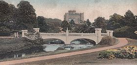
The surviving 'Tournament Bridge' was built to provide an appropriate crossing point to gain access to the far side of the Lugton Water and the Eglinton Kennels, circa 1845.
Archibald Montgomerie, the 13th Earl of Eglinton had the bridge built in a Gothic style, using cast iron for the arches, pinnacles, etc.
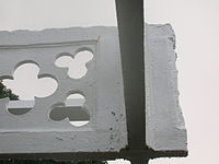
[2] The bridge's cast-iron parapet is a repetition of the pointed Gothic arch design of the castle, surmounted by a battlement, and relieved in the centre with foliated pinnacles.
It was built by Messrs Connell of Dalgarven, using parts of the original bridge and possibly to a design by David Hamilton.
[9] The original bridge, also with four pairs of miniature towers, but with three arches and four pinnacles, stood roughly 100 yards further up the river towards the castle; estate records show that it was built between 1802 and 1806[10] The original bridge is shown in several contemporary prints and maps as illustrated in the appropriate gallery of this article; the earliest is in William Aiton's book as published in 1811.
[29] At some point the height of the weir beneath had been raised using an odd assortment of re-used stonework; this would have increased the depth and extent of the waters behind it.
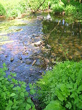
[32] Originally the river would have been crossed by simple fords, however by the 18th century ornamental pleasure gardens had been formed and these were partly situated in what later became the deer park.
A bridge was necessary to give access to the ornamental gardens and one is indicated on John Ainslie's map dated 1790, crossing the Lugton Water close to the castle itself.
The suspension bridge built by the army in the 1980s on behalf of the country park lies just below the weir beside the ruined gazebo.
Lady Jane's Cottage had a wooded pedestrian footbridge which is shown in several postcards of the time; however, no clear sign remains apart from elements of the abutment on one bank.
The restored Diamond Bridge lies upstream near the Eglinton Loch and continues to give access to the old Toll Road from Irvine to Kilwinning via Fergushill.
This bridge was named after the nearby Black Diamond mine, the spoil heap or bing of which still remains rear the Chapelholm Gate.
The width was also changed at times, for instance five ponds or lakes were created by large weirs at one stage; the one at the Tournament Bridge is clearly visible in older prints of the 1840s (see illustrations) shown.
The one below the site of the old Bowling Green and Robert Burns's garden was U-shaped, holding back sufficient water at one time to form a lake with a small island bearing a single yew tree.
Clement Wilson, the food processing factory owner, established the Clement Wilson Foundation which opened part of the grounds to the public, spending around £400,000 (around £4,317,000 in 2008 terms) on partially restoring the Tournament Bridge, consolidating the castle ruins, planting trees, landscaping, making paths, creating a rockery and waterfall feature, etc.
Historic Scotland requires a ‘faithful restoration where all details are replicated as closely as possible in terms of material, design and construction’.
The load-bearing capacity of the bridge is carried by a modern steel structure concealed beneath the wooden deck surface, as this was considered to be the original material, possibly coated with a layer of whin dust or such-like.
All of the cast-iron elements have been fabricated and fitted by the Ballantine Bo'ness Iron Company to restore the splendour of the original structure.
They were not however intended to be load bearing in the restored bridge and an upside was the degree of Gothic artwork found to exist on the arches.
Historic Scotland have indicated that they would be able to contribute some £161k, around £5k will be provided in kind, and the shortfall of £354k was the subject of the successful grant application to the Heritage Lottery Fund.