El Nido, Los Angeles County, California
El Nido (Spanish for "The Nest") is a residential neighborhood in Corral Canyon in unincorporated Los Angeles County, California, United States.
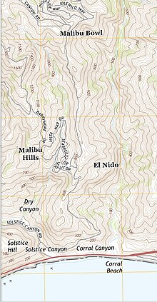
The community, originally developed in the 1920s,[2] is in the Santa Monica Mountains along the northern border of Malibu.
[3] There are two developments in Corral Canyon, El Nido is the lower of the two.
[6][2] The El Nido houses look down on Solstice Canyon, the so-called "Mystery Silo" (used by TRW and JPL scientists in the mid-20th-century for testing of satellite equipment away from sources of electromagnetic interference), and a long-disused tract owned by the DWP that is prone to landslides.
[8] The 2007 Corral Canyon fire destroyed 53 homes including a number in El Nido.